
Bérault station
Bérault | |||||||||||
|---|---|---|---|---|---|---|---|---|---|---|---|
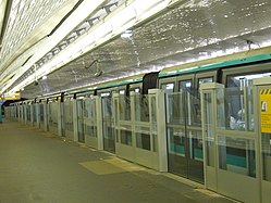
_-_2022-06-28_-_1.jpg) Platforms in 2022 | |||||||||||
| General information | |||||||||||
| Location | 29, av. de Paris 63, av. de Paris 64, av. de Paris 98, av. de Paris Vincennes Île-de-France France | ||||||||||
| Coordinates | 48°50′43″N 2°25′42″E / 48.84528°N 2.42833°E | ||||||||||
| Owned by | RATP | ||||||||||
| Operated by | RATP | ||||||||||
| Other information | |||||||||||
| Fare zone | 2 | ||||||||||
| History | |||||||||||
| Opened | 24 March 1934 | ||||||||||
| Services | |||||||||||
| |||||||||||
| Location | |||||||||||
 Bérault Location within Paris | |||||||||||
Bérault (French: [beʁo] ⓘ) is a station on Paris Métro Line 1. It is situated at the boundary between the communes of Saint-Mandé and Vincennes. It is named after the nearby Place Bérault, which honors a former deputy mayor of Vincennes (1796–1871). It also evokes the name of Bérault Stuart d'Aubigny, a captain of the guard at the Chateau de Vincennes c. 1500.
The station was the second station to be retrofitted with platform screen doors during the automation of Line 1. The platforms were heightened on 28 and 29 July 2008 and the doors were installed in March 2009.
Station layout[edit]
| G | Street Level | Exits/Entrances |
| M | Mezzanine | Connecting level, to Exits/Entrances |
| P Platform level |
Side platform with PSDs, doors will open on the right | |
| Westbound | ← | |
| Eastbound | | |
| Side platform with PSDs, doors will open on the right | ||
Wikimedia Commons has media related to Bérault (Paris Metro).
Gallery[edit]
-
 Line 1 automatic platform gates (closed)
 -
 Line 1 automatic platform gates (open)
.jpg)
.jpg)
References[edit]
- Roland, Gérard (2003). Stations de métro. D'Abbesses à Wagram. Éditions Bonneton.