Van de Graaff (crater)
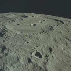
 Lunar Orbiter 2 image | |
| Coordinates | 27°24′S 172°12′E / 27.4°S 172.2°E |
|---|---|
| Diameter | 233 km |
| Depth | 4.0 km |
| Colongitude | 173° at sunrise |
| Eponym | Robert J. Van de Graaff |


Van de Graaff is a crater formation located on the far side of the Moon, on the northeast edge of Mare Ingenii.
The crater is named for physicist Robert J. Van de Graaff, whose groundbreaking work includes the invention of the Van de Graaff generator.[1]
Van de Graaff is one of the largest craters of Nectarian age.[2]
Description[edit]
Van de Graaff has the appearance of two merged craters, approximately in a figure-8 shape with no intervening rim separating the two halves.
The crater Birkeland is attached to the southeast rim, nestling against the slightly narrower "waist" of the formation. To the north is Aitken, and Nassau lies to the east.
The outer rim has some terracing along the southwest wall, but is generally in a worn and eroded state. A pair of craterlets overlay the southeast rim, next to Birkeland. There are also several small craters on the interior floor of Van de Graaff. The southwest section has a central peak, while the northeast floor is slightly smoother in form.
Orbital studies of the Moon have demonstrated that there is a local magnetic field in the vicinity of this formation that is stronger than the natural lunar field. This is most likely an indication of volcanic rock underneath the surface. The crater also has a slightly higher concentration of radioactive materials than is typical for the lunar surface.
The crater walls in the vicinity of Van de Graaff display an unusual grooved texture. This region lies at the antipode of the Mare Imbrium impact site, and it is thought that powerful seismic waves from this event converged at this point.[3] Most likely this energy created the grooved appearance as the tremors triggered landslides, although the grooves may also have been formed by deposited clumps of ejecta from the impact.
Satellite craters[edit]
By convention these features are identified on lunar maps by placing the letter on the side of the crater midpoint that is closest to Van de Graaff.
| Van de Graaff |
Latitude | Longitude | Diameter |
|---|---|---|---|
| C | 26.6° S | 172.8° E | 20 km |
| F | 26.8° S | 174.6° E | 20 km |
| J | 28.5° S | 174.1° E | 25 km |
| M | 30.6° S | 171.5° E | 19 km |
| Q | 27.6° S | 171.3° E | 15 km |
References[edit]
- ^ "Van de Graff Crater". Gazetteer of Planetary Nomenclature. USGS – Astrogeology Science Center. Retrieved 2017-03-12.
- ^ The geologic history of the Moon. USGS Professional Paper 1348. By Don E. Wilhelms, John F. McCauley, and Newell J. Trask. U.S. Government Printing Office, Washington: 1987. Table 9-4.
- ^ Seismic effects from major basin formations on the moon and mercury. Schultz, P.H. & Gault, D.E. The Moon (1975) 12: 159. https://doi.org/10.1007/BF00577875
External links[edit]
- Figure 20 in Chapter 2 of APOLLO OVER THE MOON: A View From Orbit (NASA SP-362, 1978) discusses Van de Graaff
- Andersson, L. E.; Whitaker, E. A. (1982). NASA Catalogue of Lunar Nomenclature. NASA RP-1097.
- Bussey, B.; Spudis, P. (2004). The Clementine Atlas of the Moon. New York: Cambridge University Press. ISBN 978-0-521-81528-4.
- Cocks, Elijah E.; Cocks, Josiah C. (1995). Who's Who on the Moon: A Biographical Dictionary of Lunar Nomenclature. Tudor Publishers. ISBN 978-0-936389-27-1.
- McDowell, Jonathan (July 15, 2007). "Lunar Nomenclature". Jonathan's Space Report. Retrieved 2007-10-24.
- Menzel, D. H.; Minnaert, M.; Levin, B.; Dollfus, A.; Bell, B. (1971). "Report on Lunar Nomenclature by the Working Group of Commission 17 of the IAU". Space Science Reviews. 12 (2): 136–186. Bibcode:1971SSRv...12..136M. doi:10.1007/BF00171763. S2CID 122125855.
- Moore, Patrick (2001). On the Moon. Sterling Publishing Co. ISBN 978-0-304-35469-6.
- Price, Fred W. (1988). The Moon Observer's Handbook. Cambridge University Press. ISBN 978-0-521-33500-3.
- Rükl, Antonín (1990). Atlas of the Moon. Kalmbach Books. ISBN 978-0-913135-17-4.
- Webb, Rev. T. W. (1962). Celestial Objects for Common Telescopes (6th revised ed.). Dover. ISBN 978-0-486-20917-3.
- Whitaker, Ewen A. (1999). Mapping and Naming the Moon. Cambridge University Press. ISBN 978-0-521-62248-6.
- Wlasuk, Peter T. (2000). Observing the Moon. Springer. ISBN 978-1-85233-193-1.
