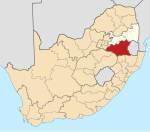
Kinross, Mpumalanga
This article needs additional citations for verification. (December 2009) |
Kinross | |
|---|---|
| Coordinates: 26°25′S 29°05′E / 26.417°S 29.083°E | |
| Country | South Africa |
| Province | Mpumalanga |
| District | Gert Sibande |
| Municipality | Govan Mbeki |
| Established | 1915 |
| Area | |
| • Total | 6.45 km2 (2.49 sq mi) |
| Population (2011)[1] | |
| • Total | 15,246 |
| • Density | 2,400/km2 (6,100/sq mi) |
| Racial makeup (2011) | |
| • Black African | 77.2% |
| • Coloured | 6.5% |
| • Indian/Asian | 8.9% |
| • White | 5.8% |
| • Other | 1.7% |
| First languages (2011) | |
| • Zulu | 38.1% |
| • English | 12.9% |
| • Afrikaans | 9.9% |
| • Sotho | 6.9% |
| • Other | 32.2% |
| Time zone | UTC+2 (SAST) |
| Postal code (street) | 2270 |
| PO box | 2270 |
| Area code | 017 |
Kinross is a small gold mining town in Mpumalanga, South Africa with four gold mines in the region. Village on the watershed between the Atlantic and Indian Oceans, between Devon and Trichardt, 42 km west of Bethal, 19 km east of Leslie and about 70 km north-north-east of Standerton.
History[edit]
Proclaimed a village in December 1915, it acquired municipal status about 1965. Named after Kinross in Scotland, some say by engineers constructing the Springs-Breyten railway, others by the surveyor of the town.[2]
Kinross mining disaster[edit]
An underground fire started by an acetylene tank caused the death of 177 miners on 16 September 1986.[3] Another 235 miners were injured in the incident, one of the largest mining incidents in South Africa.[4]
References[edit]
- ^ a b c d "Main Place Kinross". Census 2011.
- ^ "Dictionary of Southern African Place Names (Public Domain)". Human Science Research Council. p. 249.
- ^ "1986: Kinross Miners 'killed where they stood'". BBC. 16 September 1986. Retrieved 2 July 2017.
- ^ "More than 170 mineworkers are killed at Kinross Mine, South Africa". SAHistory.org.za. Retrieved 30 March 2015.


