Kitahama Station (Osaka)
Kitahama Station 北浜駅 | |||||||||||
|---|---|---|---|---|---|---|---|---|---|---|---|
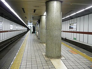
 Keihan Main Line platform (September 2007) | |||||||||||
| General information | |||||||||||
| Location | Osaka Japan | ||||||||||
| Operated by | Keihan Electric Railway | ||||||||||
| Line(s) | |||||||||||
| Platforms | 2 island platforms (1 for each line) | ||||||||||
| Tracks | 4 (2 for each line) | ||||||||||
| Connections | |||||||||||
| Construction | |||||||||||
| Structure type | Underground | ||||||||||
| Other information | |||||||||||
| Station code | KH02 (Keihan Electric Railway) K 14 | ||||||||||
| History | |||||||||||
| Opened | 1963 (Keihan Main Line) 1969 (Sakaisuji Line) | ||||||||||
| Services | |||||||||||
| |||||||||||
| Location | |||||||||||
Kitahama Station (北浜駅, Kitahama-eki) is a railway station on the Keihan Electric Railway Keihan Main Line and the Osaka Metro Sakaisuji Line in Chūō-ku, Osaka, Japan.
Kitahama is the closest station to the Osaka Securities Exchange and the financial district.
Lines[edit]
- Keihan Electric Railway
- Osaka Metro
 Sakaisuji Line (Station Number: K14)
Layout[edit]

- Keihan Electric Railway Kaihan Main Line
- There is an island platform with two tracks
| 1 | ■ Keihan Main Line | for Hirakatashi, Chushojima, Sanjo and Demachiyanagi |
| 2 | ■ Keihan Main Line | to Yodoyabashi |
- Osaka Metro Sakaisuji Line
- There is an island platform with two tracks
| 1 | ■ Sakaisuji Line | for Sakaisuji-Hommachi, Nippombashi, Dobutsuen-mae and Tengachaya |
| 2 | ■ Sakaisuji Line | for Tenjimbashisuji Rokuchome, Awaji, Kita-Senri and Takatsuki-shi |
Around the station[edit]
- Naniwa Bridge
- Nakanoshima Park
- Osaka Prefectural Nakanoshima Library
- The Museum of Oriental Ceramics, Osaka
- Naniwabashi Station on the Keihan Nakanoshima Line
- Osaka Securities Exchange
- Nomura Securities Co., Ltd. Osaka branch
- Shionogi (Doshomachi)
- The Kitahama
- Capcom
- Animation Do (subsidiary of Kyoto Animation)
Adjacent stations[edit]
| « | Service | » | ||
|---|---|---|---|---|
| Keihan Railway Keihan Main Line | ||||
| Yodoyabashi | All types | Temmabashi | ||
| Osaka Metro Sakaisuji Line K14 | ||||
| Minami-morimachi K13 | Local | Sakaisuji-Hommachi K15 | ||
| Minami-morimachi K13 | Semi-Express | Sakaisuji-Hommachi K15 | ||
| Extra Limited Express "Hozu": Does not stop at this station | ||||
External links[edit]
- (in Japanese) Kitahama Station from Osaka Metro website
- (in English) Kitahama Station from Osaka Metro website
- (in Japanese) Kitahama Station from Keihan Electric Railway website
34°41′30″N 135°30′24″E / 34.69159°N 135.506637°E


