
Eden, Wisconsin
Eden | |
|---|---|
Village | |
 Downtown Eden on US 45 | |
 Location of Eden in Fond du Lac County, Wisconsin | |
 Eden Location within the state of Wisconsin | |
| Coordinates: 43°41′35″N 88°21′42″W / 43.69306°N 88.36167°W | |
| Country | |
| State | |
| County | Fond du Lac |
| Area | |
| • Total | 0.62 sq mi (1.60 km2) |
| • Land | 0.60 sq mi (1.55 km2) |
| • Water | 0.02 sq mi (0.04 km2) |
| Population | |
| • Total | 875 |
| • Estimate (2019)[3] | 932 |
| • Density | 1,553.33/sq mi (599.47/km2) |
| Time zone | UTC-6 (Central (CST)) |
| • Summer (DST) | UTC-5 (CDT) |
| Area code | 920 |
| FIPS code | 55-22475 |
| Website | Village of Eden |
Eden is a village in Fond du Lac County, Wisconsin, United States. The population was 875 at the 2010 census. The village is located within the Town of Eden.
History[edit]
A post office called Eden was first established in 1850.[4] Eden was named after either the Garden of Eden or after John Eden, an early settler.[5]
Geography[edit]
Eden is located at 43°41′35″N 88°21′42″W / 43.69306°N 88.36167°W (43.693077, -88.361805).[6]
According to the United States Census Bureau, the village has a total area of 0.62 square miles (1.61 km2), of which 0.60 square miles (1.55 km2) of it is land and 0.02 square miles (0.05 km2) is water.[7]
Demographics[edit]
| Census | Pop. | Note | %± |
|---|---|---|---|
| 1880 | 83 | — | |
| 1920 | 176 | — | |
| 1930 | 223 | 26.7% | |
| 1940 | 223 | 0.0% | |
| 1950 | 234 | 4.9% | |
| 1960 | 312 | 33.3% | |
| 1970 | 376 | 20.5% | |
| 1980 | 534 | 42.0% | |
| 1990 | 610 | 14.2% | |
| 2000 | 687 | 12.6% | |
| 2010 | 875 | 27.4% | |
| 2019 (est.) | 932 | [3] | 6.5% |
| U.S. Decennial Census[8] | |||
2010 census[edit]
As of the census[2] of 2010, there were 875 people, 337 households, and 235 families living in the village. The population density was 1,458.3 inhabitants per square mile (563.1/km2). There were 360 housing units at an average density of 600.0 per square mile (231.7/km2). The racial makeup of the village was 94.5% White, 0.2% African American, 0.7% Native American, 0.3% Asian, 2.6% from other races, and 1.6% from two or more races. Hispanic or Latino of any race were 4.7% of the population.
There were 337 households, of which 35.6% had children under the age of 18 living with them, 55.5% were married couples living together, 8.3% had a female householder with no husband present, 5.9% had a male householder with no wife present, and 30.3% were non-families. 24.3% of all households were made up of individuals, and 9.2% had someone living alone who was 65 years of age or older. The average household size was 2.60 and the average family size was 3.09.
The median age in the village was 34.3 years. 25.5% of residents were under the age of 18; 11.4% were between the ages of 18 and 24; 26.8% were from 25 to 44; 23.6% were from 45 to 64; and 12.8% were 65 years of age or older. The gender makeup of the village was 50.2% male and 49.8% female.
2000 census[edit]
As of the census[9] of 2000, there were 687 people, 264 households, and 181 families living in the village. The population density was 1,321.2 people per square mile (510.1/km2). There were 303 housing units at an average density of 582.7 per square mile (225.0/km2). The racial makeup of the village was 98.11% White, 0.15% Native American, 1.46% from other races, and 0.29% from two or more races. 4.22% of the population were Hispanic or Latino of any race.
There were 264 households, out of which 35.2% had children under the age of 18 living with them, 58.7% were married couples living together, 7.2% had a female householder with no husband present, and 31.1% were non-families. 25.0% of all households were made up of individuals, and 10.2% had someone living alone who was 65 years of age or older. The average household size was 2.60 and the average family size was 3.16.
In the village, the population was spread out, with 30.4% under the age of 18, 6.6% from 18 to 24, 31.9% from 25 to 44, 17.5% from 45 to 64, and 13.7% who were 65 years of age or older. The median age was 34 years. For every 100 females, there were 102.7 males. For every 100 females age 18 and over, there were 98.3 males.
The median income for a household in the village was $41,579, and the median income for a family was $48,571. Males had a median income of $35,804 versus $22,031 for females. The per capita income for the village was $19,614. About 3.4% of families and 4.2% of the population were below the poverty line, including 6.5% of those under age 18 and 5.8% of those age 65 or over.
Notable people[edit]
- Warren Braun, Wisconsin politician
- Justus DaLee, folk artist
- Jim Gantner, baseball player
- Rick Gudex, Wisconsin politician
- Joseph H. Hardgrove, Wisconsin politician and physician
- Kurt W. Schuller, Wisconsin politician
Images[edit]
-
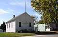 Post office / Old town hall
 -
 School
 -
 Sign on U.S. 45


References[edit]
- ^ "2019 U.S. Gazetteer Files". United States Census Bureau. Retrieved August 7, 2020.
- ^ a b "U.S. Census website". United States Census Bureau. Retrieved November 18, 2012.
- ^ a b "Population and Housing Unit Estimates". United States Census Bureau. May 24, 2020. Retrieved May 27, 2020.
- ^ "Fond du Lac County". Jim Forte Postal History. Archived from the original on April 2, 2015. Retrieved March 17, 2015.
- ^ Chicago and North Western Railway Company (1908). A History of the Origin of the Place Names Connected with the Chicago & North Western and Chicago, St. Paul, Minneapolis & Omaha Railways. p. 67.
- ^ "US Gazetteer files: 2010, 2000, and 1990". United States Census Bureau. February 12, 2011. Retrieved April 23, 2011.
- ^ "US Gazetteer files 2010". United States Census Bureau. Archived from the original on January 25, 2012. Retrieved November 18, 2012.
- ^ "Census of Population and Housing". Census.gov. Retrieved June 4, 2015.
- ^ "U.S. Census website". United States Census Bureau. Retrieved January 31, 2008.
Municipalities and communities of Fond du Lac County, Wisconsin, United States | ||
|---|---|---|
| Cities |  | |
| Villages | ||
| Towns | ||
| CDPs | ||
| Other communities |
| |
| Former communities | ||
| Footnotes | ‡This populated place also has portions in an adjacent county or counties | |