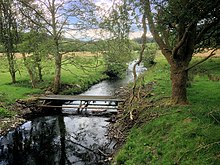
Cunsey Beck
This article needs additional citations for verification. (February 2024) |

Cunsey Beck is one of several rivers and streams that replenish the lake of Windermere in the English Lake District. Being just over two miles (3.2 km) in length and generally slow flowing, the stream descends some 87 feet (27 m) from the southern end of Esthwaite Water, which it drains, to the western banks of Windermere near an island called Ling Holm.[1]
After flowing out of Esthwaite Water, the Cunsey Beck replenishes the small Out Dubs Tarn. Draining the tarn at its southern end, the beck then flows in a south-easterly direction between the conifer-wooded slopes of Grizedale Forest to the south and west, and the deciduous woodland of Bishop Woods to the north. Just before entering Windermere, the beck passes through the deciduous Cunsey Wood. Immediately before entering the lake, Cunsey Beck is crossed by a footbridge, which is part of a public footpath along a stretch of the western shore of Windermere.
In 2022 the beck was the scene of a major pollution incident and many fish were killed.[1][2] Local campaigners believe the cause was inadequately investigated at the time.[3][4]
See also[edit]
References[edit]
- ^ a b Fletcher, Joe (23 June 2022). "'Disaster' as pollution strikes beck in Lake District". The Westmorland Gazette. Retrieved 16 February 2024.
- ^ Laville, Sandra (23 January 2024). "Huge loss of invertebrates detected in stream feeding into Windermere". The Guardian. Retrieved 16 February 2024.
- ^ "Save Windermere demands Environment Agency reopens Cunsey Beck fish kill investigation". Save Windermere. Retrieved 16 February 2024.
- ^ "How events unfolded in the Cunsey Beck pollution cover-up". Wildfish. 18 December 2023. Retrieved 16 February 2024.
54°20′03″N 2°56′53″W / 54.3343°N 2.9480°W
