
Pasighat
Pasighat | |
|---|---|
Town | |
 A view of Pasighat from Hotel Siang | |
 Pasighat Location in Arunachal Pradesh, India  Pasighat Pasighat (India) | |
| Coordinates: 28°04′N 95°20′E / 28.07°N 95.33°E | |
| Country | |
| State | Arunachal Pradesh |
| District | East Siang |
| Government | |
| • Type | Multi Party democracy |
| • Deputy Commissioner | Mr. Tayi Taggu, IAS |
| Area | |
| • Total | 14.60 km2 (5.64 sq mi) |
| Elevation | 152 m (499 ft) |
| Population (2011)[1] | |
| • Total | 24,656 |
| • Density | 1,504.9/km2 (3,898/sq mi) |
| Languages[2][3] | |
| • Official | |
| Time zone | UTC+5:30 (IST) |
| PIN | 791102 |
| Telephone code | 0368 |
| ISO 3166 code | IN-AR |
| Vehicle registration | AR-09 |
| Climate | Cwa |
| Website | www |
Pasighat is the headquarters of East Siang district in the Indian state of Arunachal Pradesh. Situated at the eastern foothills of the Himalayas at 155 metres (509 ft) above mean sea level, Pasighat is Arunachal's oldest town.[4] The Government of India included Pasighat in the Smart Cities Mission development scheme in June 2017.
It is also an Advance Landing Ground (ALG) of Indian Air Force.
History[edit]
Pasighat was founded in 1911 by the British Raj as a gateway to administrative convenience of the greater Abor Hills and the north area in general. Primarily there were settlements of Adi tribesmen who are still living in the villages in and around Pasighat.
Cognizance of Pasighat emerged due to the last Anglo-Abor War that was fought in 1912 subsequent to the fourth Anglo-Abor War in 1894. This necessitated the first-ever administrative headquarters being established here with an Assistant Political Officer posted. In the post-independence era, Pasighat is credited with the first Airfield (near Paglek, P. I. Line) established in 1946.[citation needed]
The first Agricultural Institute in Arunachal Pradesh was also established at Pasighat in 1950. Other forms of later infrastructural development include:
- General Hospital (established 1954, although some claim it as old as the town itself)
- Co-operative society Ltd (1957)
- Nurse Training Centre (affiliated to General Hospital)
- Jawaharlal Nehru College - the first college in Arunachal Pradesh (established 3 July 1964[5])
- The first All India Radio Station in the state in 1966.
- Govt.Polytechnic College, Pasighat.
- College of Horticulture and Forestry, CAU. (2001)
- Pasighat Airport
- Rashtriya Raksha University, Pasighat
Early proponents for moving the state capital from Shillong (the then NEFA), underlined Pasighat's better infrastructure. However, the privilege was lost to the present capital Itanagar in 1974. The only significant development in Pasighat that came after that was the College Of Horticulture and Forestry Central Agriculture University established on 7 March 2001.
Geography[edit]
Pasighat is located at 28°04′N 95°20′E / 28.07°N 95.33°E.[6] It has an average elevation of 153 metres or 502 feet. Pasighat has a typical lowland Northeast India humid subtropical climate (Köppen Cwa) a little too cool to qualify as a tropical monsoon climate (Am).
The unique trough-like features surrounded by high hills on three sides make Pasighat ideal for attracting rain-bearing clouds that come in from the Assam plain. The rain-bearing wind gets obstructed by the hills and brings exceptionally heavy rainfall from June to September when the average monthly rainfall is 796 millimetres or 31.34 inches – equivalent to over 1 inch or 25.4 millimetres per day. Winter is marked by strong, cool, dry northeasterly winds from the Siberian High, which make Pasighat fog-free even in winter. Days during the “cool” season from November to February are generally warm and clear, whilst the “hot” spring season from March to May sees an increasing frequency of heavy thunder downpours and very warm to hot, humid weather with even mornings warm.
The Brahmaputra River emerges from the foothills under the name of Dihang or Siang in Pasighat. It enters the plains from here, in the west of Sadiya town in Arunachal Pradesh. Flowing south-west, it receives its main left-bank tributaries, viz. Dibang and Lohit; thereafter, it is known as the Brahmaputra in the plains. Then it crosses the Pasighat area heading for the Assam plains.
Climate[edit]
| Climate data for Pasighat (1981–2010, extremes 1957–present) | |||||||||||||
|---|---|---|---|---|---|---|---|---|---|---|---|---|---|
| Month | Jan | Feb | Mar | Apr | May | Jun | Jul | Aug | Sep | Oct | Nov | Dec | Year |
| Record high °C (°F) | 29.6 (85.3) |
34.0 (93.2) |
34.0 (93.2) |
37.3 (99.1) |
37.4 (99.3) |
38.6 (101.5) |
38.8 (101.8) |
38.5 (101.3) |
38.0 (100.4) |
36.2 (97.2) |
33.0 (91.4) |
30.2 (86.4) |
38.8 (101.8) |
| Mean maximum °C (°F) | 26.9 (80.4) |
28.9 (84.0) |
31.6 (88.9) |
33.1 (91.6) |
35.4 (95.7) |
36.2 (97.2) |
36.2 (97.2) |
36.0 (96.8) |
35.6 (96.1) |
33.4 (92.1) |
30.9 (87.6) |
27.6 (81.7) |
36.5 (97.7) |
| Mean daily maximum °C (°F) | 23.1 (73.6) |
23.8 (74.8) |
25.5 (77.9) |
27.1 (80.8) |
29.8 (85.6) |
30.8 (87.4) |
30.2 (86.4) |
31.6 (88.9) |
30.6 (87.1) |
29.6 (85.3) |
27.7 (81.9) |
24.3 (75.7) |
27.8 (82.1) |
| Daily mean °C (°F) | 17.9 (64.2) |
19.1 (66.4) |
21.2 (70.2) |
23.1 (73.6) |
25.7 (78.3) |
27.2 (81.0) |
27.0 (80.6) |
27.9 (82.2) |
26.9 (80.4) |
25.3 (77.5) |
22.4 (72.3) |
19.0 (66.2) |
23.5 (74.3) |
| Mean daily minimum °C (°F) | 12.7 (54.9) |
14.5 (58.1) |
17.0 (62.6) |
19.2 (66.6) |
21.7 (71.1) |
23.6 (74.5) |
23.9 (75.0) |
24.3 (75.7) |
23.3 (73.9) |
21.1 (70.0) |
17.1 (62.8) |
13.7 (56.7) |
19.3 (66.8) |
| Mean minimum °C (°F) | 9.7 (49.5) |
11.4 (52.5) |
13.7 (56.7) |
15.8 (60.4) |
18.4 (65.1) |
21.3 (70.3) |
21.6 (70.9) |
22.2 (72.0) |
21.2 (70.2) |
17.9 (64.2) |
14.0 (57.2) |
10.6 (51.1) |
9.3 (48.7) |
| Record low °C (°F) | 6.5 (43.7) |
6.6 (43.9) |
10.6 (51.1) |
12.5 (54.5) |
11.3 (52.3) |
18.9 (66.0) |
19.1 (66.4) |
20.1 (68.2) |
17.4 (63.3) |
13.4 (56.1) |
8.3 (46.9) |
7.2 (45.0) |
6.5 (43.7) |
| Average rainfall mm (inches) | 47.0 (1.85) |
101.3 (3.99) |
163.9 (6.45) |
291.0 (11.46) |
386.3 (15.21) |
786.1 (30.95) |
1,134.9 (44.68) |
667.5 (26.28) |
600.7 (23.65) |
190.6 (7.50) |
33.2 (1.31) |
26.0 (1.02) |
4,428.5 (174.35) |
| Average rainy days | 3.6 | 7.4 | 10.7 | 13.9 | 13.2 | 18.7 | 22.0 | 15.5 | 15.0 | 7.8 | 2.3 | 1.9 | 132.0 |
| Average relative humidity (%) (at 17:30 IST) | 72 | 70 | 71 | 75 | 76 | 82 | 86 | 83 | 84 | 82 | 77 | 74 | 77 |
| Source: India Meteorological Department[7][8][9] | |||||||||||||
Economy[edit]
Agriculture is the main occupation of the local people. Rice is the main food crop produced in the area. There are several large tea gardens in the vicinity of the town which attract workers from all over the region. Lumbering was a big sustaining industry till the Supreme Court clamped down on the industry during the 1990s. There is also a bit of tourism in Pasighat, being the oldest town in Arunachal Pradesh. Agriculture, horticulture, and tourism continue to be the main source of economy for the town.
Demography[edit]

As of 2011 India Census,[10] Pasighat had a population of 24,656.[11] Males constitute 50.62% (12,482 males) of the population and females 49.37% (12,174 females). Pasighat has an average literacy rate of 79.6%: male literacy is 85.33%, and female literacy is 73.74%. In Pasighat, 12% of the population is under 6 years of age.
Pasighat is predominantly inhabited by the Adi people.
Languages[edit]
According to 2011 census, Adi was the most spoken language with 9,074 speakers followed by Nepali at 4,269, Bengali at 2,621, Bhojpuri at 2,511, Hindi at 1,905 and Assamese at 1,181.
Culture[edit]
The people of Pasighat celebrate a variety of festivals. Solung, Aran, and Etor are important festivals. Legend has it that the festival regarded as Solung, which is the principal festival of the Adi, came into existence when the Goddess of wealth, Kiine-Naane, had asked them in person to carry out this worship or 'puja'.
Solung is celebrated by the Adis for five days in the month of September. The first day or the Solung Gidi Dogin is the day when they prepare for this event. Doreph Long, the second day is the day of animal slaughters. Binnyat Binam or the third day is the day of prayers. Taktor of Ekoph is the fourth day and on this day arms and ammunition are manufactured. Miri or the fifth day is the day of farewell.
The Adi people are known for their colourful Ponung dance and war dance called Taapu.
Transport connectivity[edit]
.jpg)
Pasighat is connected by the NH-515 and have frequent services from Guwahati, Lakhimpur and Itanagar. Waterways crossing the Brahmaputra River from Dibrugarh by ferry to Oryamghat that is situated at a distance of 32 km from Pasighat and can take a bus or taxi. Nearest rail head is at Murkongselek which is terminal station of the Rangia-Murkongselek broad gauge track.[13]
The 227-km Murkongselek-Pasighat-Tezu-Rupai line is being undertaken as a strategic project.[14][15] The rail head is proposed to be extended up to Pasighat. The BG railway line will link North-Assam area with Pasighat town, the district headquarter of East Siang of Arunachal, located at a rail route distance of 26.5 km. About 24.5 km of the route falls in Arunachal territory. The Rangia - Murkongselek BG conversion (with extension up to Pasighat) project was one of the two major rail projects in Northeast announced by Prime Minister Manmohan Singh during 2010. This broad gauge line is supposed to be proceeding on to Roing, Parsuramkund, Rupai, and other places in the state. A preliminary engineering-traffic survey for the Pasighat-Tezu-Parshuram Kund was conducted by Northeast Frontier Railways at the request of the state government.[13]Arunachal Pradesh State Transport Services (APSTS) is another means of transportation in the district which is linked with other districts and nearby villages. APSTS buses are also run from Pasighat to Itanagar, the capital of the state, from Pasighat to Shillong, Meghalaya via Guwahati on the daily basis. Bus services are available to Guwahati, Assam which are run by private operators. Private-owned Winger and Tata Sumo services also run across the district and run in the other districts. Also, regular flights from Pasighat to Guwahati and Guwahati to Pasighat on selected weekdays have also started since April 2018. Guwahati and Kolkata are connected with Pasighat Airport by Alliance Air.
Tourism[edit]
This section is written like a travel guide. (July 2013) |

Pasighat is the land of the Siang river and indigenous hanging bridges[according to whom?]. A waterfall graces the mountain cliffs and chills the vicinity. Attractions in the town include:
- The Daying Ering Wildlife Sanctuary in Arunachal Pradesh, India is one of the most popular wildlife parks of the state. Spread over an area of 190 square kilometres (73 sq mi), alluvial grasslands form the major area and wooded areas constitute about 15%. The rest of the area is water. The present land of the sanctuary was mostly donated by the Mebo and Monngu Banngos. It is popularly called Jopong, which was a named given by locals and land owners in memory of Rutum Jotan Pertin during 1790s[according to whom?].
- Pangin is about 60 kilometres (37 mi) from Pasighat, and is connected by road. It stands at a point where River Siyom meets River Siang and the blue waters of Siyom meet the green Siang. There are rare plants and herbs which are of medicinal importance. Botanists and Zoologists can have ample scope for study of the rich plant and wildlife resources.
- Bodak Scenic Area: The Bodak-Mebo-Jengging Scenic Area is a popular picnic spot for tourists. The scenic area is a large forested area with villages, agricultural lands within, at about 15 kilometres away from the Pasighat main town. The scenic area is along the highway starting from the Siang Bridge and diverges to Mebo village on the right hand side and to Jengging village on the left hand side. The road to Jenning is much more frequented because of the vistas of the Siang river from the road. The area is also home to the Mïdu Lereng stone monolith. Villagers of the area have shown concern about the garbage generated and destruction to the environment from frequent tourist visits and many regular picnic spots are now taxed by NGOs who help maintain the environment.
- Kekar Monying: A mountain cliff near Rottung which is an important historical place because it was here that the Adi put up a strong resistance against the British in 1911. The war was a part of a punitive expedition undertaken by the British for murdering Noel Williamson, a political officer in the previous year by Matmur Jamoh, a native of Yagrung village.
- Komsing: A village on the left bank of the Siang is the place of Williamson's murder. A stone epitaph bearing the name of Noel Williamson lies near the Siang.
- Komlighat used to be a river port at an earlier time. The ghat marks the area of the colonial town of Pasighat which has been submerged into the Siang river following a flood and the river changing its course. The spot is also popular for its street food sold by vendors in the area. The ghat provides a wonderful view of the river and the hills surrounding the Pasighat plains. The distant hills are covered with snow in winters.
- Pasighat Buddhist Temple: Located in the opposite side of the air strip from the highway, this small temple serves as the only Buddhist worship place in Pasighat.
- East Siang District Museum: Also located in the opposite side of the Pasighat Airport, it is the district museum of the East Siang District.
- Adi Baane Kebang Headquarters: Pasighat also houses the headquarters of the Adi Baane Kebang, which acts as the de facto cultural parliament governing the cultural, linguistic, traditional aspects of the Adi people.
- Pasighat Airport is a military airstrip, which has been upgraded and is also being used as a civilian airport.
- Gomsi: A cultivation area near Rani Village is another place of historical importance. In June 1996, a team of archaeologists conducted a trial excavation and survey in the site. They found evidence of culture of early medieval period (probably Pre-Ahom).
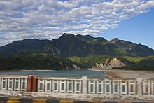
River Siang (Brahmaputra) entering into the plains at Ranaghat, on the east of Pasighat
_entering_into_the_plains_at_Ranaghat,_on_the_east_of_Roing.jpg)
See also[edit]
- Military bases
- List of ALGs
- List of Indian Air Force stations
- India-China military deployment on LAC
- List of disputed India-China areas
- Tianwendian
- Ukdungle
- Borders
- Conflicts
- Other related topics
- India-China Border Roads
- List of extreme points of India
- Defence Institute of High Altitude Research
- Independent Golden Jubilee Government Higher Secondary School, Pasighat
References[edit]
- ^ "Census of India Search details". censusindia.gov.in. Retrieved 10 May 2015.
- ^ "1977 Sikkim government gazette" (PDF). sikkim.gov.in. Governor of Sikkim. p. 188. Archived from the original (PDF) on 22 July 2018. Retrieved 28 May 2019.
- ^ "50th Report of the Commissioner for Linguistic Minorities in India" (PDF). 16 July 2014. p. 109. Archived from the original (PDF) on 2 January 2018. Retrieved 28 May 2019.
- ^ Pasighat: Oldest town of Arunachal Pradesh Archived 26 January 2011 at the Wayback Machine. All India Radio.
- ^ "JAWAHARLAL NEHRU COLLEGE". Retrieved 17 June 2020.
- ^ "Maps, Weather, and Airports for Pasighat, India". www.fallingrain.com.
- ^ "Station: Pasighat (A) Climatological Table 1981–2010" (PDF). Climatological Normals 1981–2010. India Meteorological Department. January 2015. pp. 595–596. Archived from the original (PDF) on 5 February 2020. Retrieved 5 February 2020.
- ^ "Extremes of Temperature & Rainfall for Indian Stations (Up to 2012)" (PDF). India Meteorological Department. December 2016. p. M21. Archived from the original (PDF) on 5 February 2020. Retrieved 5 February 2020.
- ^ "Passighat Climatological Table 1971–2000". India Meteorological Department. Retrieved 5 February 2020.
- ^ "Census of India 2001: Data from the 2001 Census, including cities, villages and towns (Provisional)". Census Commission of India. Archived from the original on 16 June 2004. Retrieved 1 November 2008.
- ^ ORGI. "Census of India Website : Office of the Registrar General & Census Commissioner, India". censusindia.gov.in. Retrieved 13 November 2017.
- ^ "C-16: Population by mother tongue, Arunachal Pradesh - 2011".
- ^ a b "Solace to suffering humanity would surface from Arunachal, believes Shankaracharya". ANI. Archived from the original on 19 August 2014. Retrieved 16 January 2014.
- ^ India to construct strategic railway lines along border with China, Hindustan Times, 30 Nov 2016.
- ^ 2019 target to survey 3 strategic rail lines along China border, Arunachal Observer, January 5, 2019.
External links[edit]
| Leadership | |||||||||||||||||||||||||||||||||||||||||||||||||||||
|---|---|---|---|---|---|---|---|---|---|---|---|---|---|---|---|---|---|---|---|---|---|---|---|---|---|---|---|---|---|---|---|---|---|---|---|---|---|---|---|---|---|---|---|---|---|---|---|---|---|---|---|---|---|
| Components & commands |
| ||||||||||||||||||||||||||||||||||||||||||||||||||||
| Military academies |
| ||||||||||||||||||||||||||||||||||||||||||||||||||||
| Insignia | |||||||||||||||||||||||||||||||||||||||||||||||||||||
| History & future | |||||||||||||||||||||||||||||||||||||||||||||||||||||
| Other | |||||||||||||||||||||||||||||||||||||||||||||||||||||
| International | |
|---|---|
| National | |