
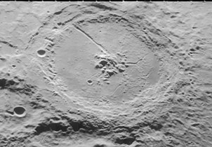
Petavius (crater)
 LRO mosaic | |
| Coordinates | 25°18′S 60°24′E / 25.3°S 60.4°E |
|---|---|
| Diameter | 177 km |
| Depth | 3.4 km |
| Colongitude | 300° at sunrise |
| Eponym | Denis Pétau |
Petavius is a large lunar impact crater located to the southeast of the Mare Fecunditatis, near the southeastern lunar limb. Attached to the northwest rim is the smaller crater Wrottesley. To the southeast are Palitzsch, Vallis Palitzsch, and Hase. Farther to the north is the large crater Vendelinus. Petavius appears oblong when viewed from the Earth due to foreshortening. Petavius is Imbrian in age.
The outer wall of Petavius is unusually wide in proportion to the diameter, and displays a double rim along the south and west sides. The height of the rim varies by as much as 50% from the lowest point, and a number of ridges radiate outwards from the rim. The convex crater floor has been resurfaced by lava flow, and displays a rille system named the Rimae Petavius. The large central mountains are a prominent formation with multiple peaks, climbing 1.7 kilometers above the floor. A deep fracture runs from the peaks toward the southwest rim of the crater.
Rev. T. W. Webb described Petavius as,
- "one of the finest spots in the Moon: its grand double rampart, on east side nearly 11,000 ft (3,400 m). High, its terraces, and convex interior with central hill and cleft, compose a magnificent landscape in the lunar morning or evening, entirely vanishing beneath a Sun risen but halfway to the meridian."
Petavius is one of the largest craters of Lower (Early) Imbrian age.[1]
The most favorable time for viewing this feature through a telescope is when the Moon is only three days old. By the fourth day the crater is nearly devoid of shadow.
70-cm radar images of this crater and its surroundings show that the region of the surface beyond the wide outer rampart of Petavius has a dark halo, characteristic of a smooth surface free of boulders. It is thought that this may have been created by radial outbursts during the original impact that swept the area clean.
Petavius B to the north-northwest of Petavius has a small ray system that lies across the surface of Mare Fecunditatis. Due to these rays, Petavius B is mapped as part of the Copernican System.[2]
Satellite craters[edit]
By convention these features are identified on lunar maps by placing the letter on the side of the crater midpoint that is closest to Petavius.
| Petavius | Latitude | Longitude | Diameter |
|---|---|---|---|
| A | 26.0° S | 61.6° E | 5 km |
| B | 19.9° S | 57.1° E | 33 km |
| C | 27.7° S | 60.1° E | 11 km |
| D | 24.0° S | 64.4° E | 17 km |
Views[edit]
-
 Oblique view from Lunar Orbiter 4
 -
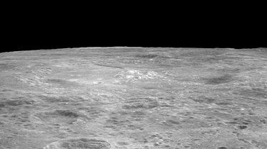 Oblique view from Apollo 17
 -
 Petavius crater at the terminator, from Earth
 -
 Petavius crater viewed from Earth
 -
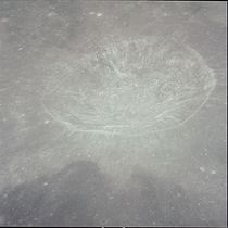 Petavius B crater, from Apollo 12


References[edit]
- ^ The geologic history of the Moon. USGS Professional Paper 1348. By Don E. Wilhelms, John F. McCauley, and Newell J. Trask. U.S. Government Printing Office, Washington: 1987. Table 10.2.
- ^ The geologic history of the Moon, 1987, Wilhelms, Don E.; with sections by McCauley, John F.; Trask, Newell J. USGS Professional Paper: 1348. Plate 11: Copernican System (online)
- Rev. T. W. Webb, Celestial Objects for Common Telescopes, rev. 6, Dover, 1962, ISBN 0-486-20917-2.
- Ghent and others, Properties of Lunar Crater Ejecta from New 70 cm Radar Observations, 2004, Lunar & Planetary Science 35; #1879.
- Andersson, L. E.; Whitaker, E. A. (1982). NASA Catalogue of Lunar Nomenclature. NASA RP-1097.
- Blue, Jennifer (July 25, 2007). "Gazetteer of Planetary Nomenclature". USGS. Retrieved 2007-08-05.
- Bussey, B.; Spudis, P. (2004). The Clementine Atlas of the Moon. New York: Cambridge University Press. ISBN 978-0-521-81528-4.
- Cocks, Elijah E.; Cocks, Josiah C. (1995). Who's Who on the Moon: A Biographical Dictionary of Lunar Nomenclature. Tudor Publishers. ISBN 978-0-936389-27-1.
- McDowell, Jonathan (July 15, 2007). "Lunar Nomenclature". Jonathan's Space Report. Retrieved 2007-10-24.
- Menzel, D. H.; Minnaert, M.; Levin, B.; Dollfus, A.; Bell, B. (1971). "Report on Lunar Nomenclature by the Working Group of Commission 17 of the IAU". Space Science Reviews. 12 (2): 136–186. Bibcode:1971SSRv...12..136M. doi:10.1007/BF00171763. S2CID 122125855.
- Moore, Patrick (2001). On the Moon. Sterling Publishing Co. ISBN 978-0-304-35469-6.
- Price, Fred W. (1988). The Moon Observer's Handbook. Cambridge University Press. ISBN 978-0-521-33500-3.
- Rükl, Antonín (1990). Atlas of the Moon. Kalmbach Books. ISBN 978-0-913135-17-4.
- Webb, Rev. T. W. (1962). Celestial Objects for Common Telescopes (6th revised ed.). Dover. ISBN 978-0-486-20917-3.
- Whitaker, Ewen A. (1999). Mapping and Naming the Moon. Cambridge University Press. ISBN 978-0-521-62248-6.
- Wlasuk, Peter T. (2000). Observing the Moon. Springer. ISBN 978-1-85233-193-1.
External links[edit]
- Lunar Orbiter 5 acquired high-resolution images of Petavius: Frame 033, Frame 034, Frame 035, and Frame 036
- Wood, Chuck (May 26, 2005). "A New Kind of DHC". Lunar Photo of the Day. Archived from the original on December 28, 2005. Retrieved 2005-05-26.
- Wood, Chuck (December 12, 2006). "Trenchent Observations of a Trench". Lunar Photo of the Day. Archived from the original on September 29, 2007. Retrieved 2006-12-12.
- Wood, Chuck (February 21, 2007). "The Hase–Petavius Rille". Lunar Photo of the Day. Archived from the original on September 29, 2007. Retrieved 2007-02-21.
- Wood, Chuck (November 20, 2007). "Limb Gift". Lunar Photo of the Day. Archived from the original on November 21, 2007. Retrieved 2007-11-20.