
Maragondon
This article needs additional citations for verification. (October 2021) |
Maragondon | |
|---|---|
| Municipality of Maragondon | |
 Municipal plaza | |
 Flag  Seal | |
| Nickname: Historic Town & Wildlife Sanctuary | |
 Map of Cavite with Maragondon highlighted | |
OpenStreetMap  | |
.svg) Maragondon Location within the Philippines | |
| Coordinates: 14°16′N 120°44′E / 14.27°N 120.73°E | |
| Country | Philippines |
| Region | Calabarzon |
| Province | Cavite |
| District | 8th district |
| Founded | 1727 |
| Barangays | 27 (see Barangays) |
| Government | |
| • Type | Sangguniang Bayan |
| • Mayor | Lawrence N. Arca |
| • Vice Mayor | Bernie P. Ilagan |
| • Representative | Aniela Bianca D. Tolentino |
| • Municipal Council | Members |
| • Electorate | 33,062 voters (2022) |
| Area | |
| • Total | 164.61 km2 (63.56 sq mi) |
| Elevation | 77 m (253 ft) |
| Highest elevation | 1,409 m (4,623 ft) |
| Lowest elevation | 0 m (0 ft) |
| Population (2020 census)[3] | |
| • Total | 40,687 |
| • Density | 250/km2 (640/sq mi) |
| • Households | 9,770 |
| Economy | |
| • Income class | 3rd municipal income class |
| • Poverty incidence | 6.14 |
| • Revenue | ₱ 157.2 million (2020) |
| • Assets | ₱ 344.3 million (2020) |
| • Expenditure | ₱ 134.6 million (2020) |
| • Liabilities | ₱ 119.9 million (2020) |
| Service provider | |
| • Electricity | Manila Electric Company (Meralco) |
| Time zone | UTC+8 (PST) |
| ZIP code | 4112 |
| PSGC | |
| IDD : area code | +63 (0)46 |
| Native languages | Tagalog |
| Major religions | |
| Feast date | August 15 |
| Catholic diocese | Diocese of Imus |
| Patron saint | Our Lady of Assumption |
| Website | www |
Maragondon, officially the Municipality of Maragondon (Tagalog: Bayan ng Maragondon), is a 3rd class municipality in the province of Cavite, Philippines. According to the 2020 census, it has a population of 40,687 people.[3] The town is famous for its bamboo crafts, Mounts Palay-Palay–Mataas-na-Gulod Protected Landscape which includes Mount Pico de Loro, and various ancestral houses and structures important to Philippine history and culture such as Maragondon Church and the execution site and trial house of national hero Andres Bonifacio.[5][6]
History[edit]

The name Maragondon is a Spanish approximation of the Tagalog word maragundong or madagundong, which means "having a rumbling or thunderous sound".[7] This refers to the noise coming from the Kay Albaran river in the village of Capantayan. This was initially the place on which the town was to be built. However, due to the floods caused by the frequent overflowing of the river, the town was later relocated to its present site.
Incidentally, Maragondon has three foundation dates; namely, 1. ) 1611 when the Franciscan Fathers from Silang established their first visita or chapel; 2.) 1690, the fundacion ecclesiastica or founding of the regular parish by the Jesuits, dedicating it to Our Lady of the Assumption; 3.) 1727, the fundacion civil, when the original barrio of Maragondon was separated from Silang during the administration of the Recollects and converted into an independent municipality with Gregorio Silvestre as the first gobernadorcillo. Maragondon belonged to the corregimiento of Mariveles (now Bataan province) until 1754, when Spanish governor general Pedro Manuel de Arandia (1754–1759) abolished the politico-military administration and restored Maragondon to Cavite province. Alongside Silang, the town's territory was very large during its early decades.
In the second half of the 19th century the towns of Ternate, Magallanes, Gen. Emilio Aguinaldo (formerly Bailen), Alfonso, and Naic were mere barangays of Maragondon. Ternate was the first town to attain full independence on March 31, 1857, under an agreement signed by Tomas de Leon, Felix Nigosa, Pablo de Leon, Florencio Nino Franco and Juan Ramos in behalf of the people of Ternate.
Furthermore, Bailen (now Gen. Aguinaldo) and Alfonso seceded from Maragondon in 1858. Naic then severed as a town in 1869. Magallanes was the last of the villages to attain independence, having been founded on July 15, 1879, under an agreement signed by Crisostomo Riel representing Maragondon, and by Isidro Bello and company representing Magallanes.
Geography[edit]
Barangays[edit]
Maragondon is politically subdivided into 27 barangays. [8] Each barangay consists of puroks and some have sitios.
- Bucal 1
- Bucal 2
- Bucal 3A
- Bucal 3B
- Bucal 4A
- Bucal 4B
- Caingin Pob.
- Garita 1A
- Garita 1B
- Layong Mabilog
- Mabato
- Pantihan 1 (Balayungan)
- Pantihan 2
- Pantihan 3 (Pook na Munti)
- Pantihan 4 (Pulo ni Sara)
- Patungan
- Pinagsanhan A (Ibayo)
- Pinagsanhan B (Ibayo)
- Poblacion 1A
- Poblacion 1B
- Poblacion 2A
- Poblacion 2B
- San Miguel A (Caputatan)
- San Miguel B (Caputatan)
- Talipusngo
- Tulay Silangan (Mabacao)
- Tulay Kanluran (Mabacao)
Climate[edit]
| Climate data for Maragondon, Cavite | |||||||||||||
|---|---|---|---|---|---|---|---|---|---|---|---|---|---|
| Month | Jan | Feb | Mar | Apr | May | Jun | Jul | Aug | Sep | Oct | Nov | Dec | Year |
| Mean daily maximum °C (°F) | 29 (84) |
30 (86) |
32 (90) |
34 (93) |
32 (90) |
31 (88) |
29 (84) |
29 (84) |
29 (84) |
30 (86) |
30 (86) |
29 (84) |
30 (87) |
| Mean daily minimum °C (°F) | 20 (68) |
20 (68) |
21 (70) |
22 (72) |
24 (75) |
24 (75) |
24 (75) |
24 (75) |
24 (75) |
23 (73) |
22 (72) |
21 (70) |
22 (72) |
| Average precipitation mm (inches) | 10 (0.4) |
10 (0.4) |
12 (0.5) |
27 (1.1) |
94 (3.7) |
153 (6.0) |
206 (8.1) |
190 (7.5) |
179 (7.0) |
120 (4.7) |
54 (2.1) |
39 (1.5) |
1,094 (43) |
| Average rainy days | 5.2 | 4.5 | 6.4 | 9.2 | 19.7 | 24.3 | 26.9 | 25.7 | 24.4 | 21.0 | 12.9 | 9.1 | 189.3 |
| Source: Meteoblue[9] | |||||||||||||
Demographics[edit]
| Year | Pop. | ±% p.a. |
|---|---|---|
| 1903 | 7,191 | — |
| 1918 | 7,266 | +0.07% |
| 1939 | 9,449 | +1.26% |
| 1948 | 8,465 | −1.21% |
| 1960 | 9,994 | +1.39% |
| 1970 | 12,743 | +2.46% |
| 1975 | 14,785 | +3.03% |
| 1980 | 18,018 | +4.03% |
| 1990 | 22,814 | +2.39% |
| 1995 | 25,828 | +2.35% |
| 2000 | 31,227 | +4.15% |
| 2007 | 33,604 | +1.02% |
| 2010 | 35,289 | +1.80% |
| 2015 | 37,720 | +1.28% |
| 2020 | 40,687 | +1.50% |
| Source: Philippine Statistics Authority[10][11][12][13] | ||
In the 2020 census, the population of Maragondon was 40,687 people,[3] with a density of 250 inhabitants per square kilometre or 650 inhabitants per square mile.
Government[edit]
Elected officials[edit]
The following are the elected officials of the town elected last May 09, 2022 which serves until 2025:
| Position | Official |
|---|---|
| Mayor | Lawrence N. Arca (LP) |
| Vice Mayor | Bernie P. Ilagan (NUP) |
| Sangguniang Bayan Members | Party |
|---|---|
| Reagan E. Gulapa | NUP |
| Emil P. Digal | LP |
| Alexander V. Villanueva | NUP |
| Bonn B. Rillo | LP |
| Reciel P. Diño | LP |
| Angelita M. De Joya | NUP |
| Alexander Alan S. Angeles | NPC |
| Joel A. Perio | LP |
| ABC President | |
| Rommel A. Manalo | |
| SK Federation President | |
| Jan Robby Tanagras |
Images[edit]
-
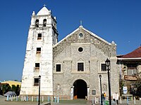 Our Lady of the Assumption, Maragondon
 -
 Maragondon Parochial School
 -
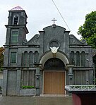 Iglesia Filipina Independiente (Aglipayan) Parish of the Virgin of the Assumption in Maragondon, Cavite.
 -
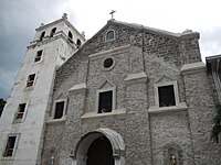 Our Lady of the Assumption Parish Church
 -
 Welcome arch
 -
 Barangay Poblacion 1-B
 -
 Public market
 -
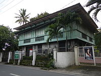 Bonifacio Trial House
 -
 Mt. Pico De Loro Monolith
 -
 Silyang Bato of Mt. Marami
 -
 Kaybiang Tunnel


.jpg)


References[edit]
- ^ Municipality of Maragondon | (DILG)
- ^ "2015 Census of Population, Report No. 3 – Population, Land Area, and Population Density" (PDF). Philippine Statistics Authority. Quezon City, Philippines. August 2016. ISSN 0117-1453. Archived (PDF) from the original on May 25, 2021. Retrieved July 16, 2021.
- ^ a b c Census of Population (2020). "Region IV-A (Calabarzon)". Total Population by Province, City, Municipality and Barangay. Philippine Statistics Authority. Retrieved 8 July 2021.
- ^ "PSA Releases the 2018 Municipal and City Level Poverty Estimates". Philippine Statistics Authority. 15 December 2021. Retrieved 22 January 2022.
- ^ "The Official Website of the Municipality of Maragondon – Home". maragondon-official.cavite.gov.ph.
- ^ "Maragondon's Natural Wonders: 10 Reasons to Choose the Town That Has It All (Prequel) - Choose Philippines. Find. Discover. Share". Archived from the original on 2019-01-08. Retrieved 2019-01-08.
- ^ Lesho, Marivic; Sippola, Eeva (2018). "Toponyms in Manila and Cavite, Philippines". Vergleichende Kolonialtoponomastik Strukturen und Funktionen kolonialer Ortsbenennung. De Gruyter. pp. 317–332. ISBN 9783110608618.
- ^ "Province: Cavite". PSGC Interactive. Quezon City, Philippines: Philippine Statistics Authority. Retrieved 12 November 2016.
- ^ "Maragondon: Average Temperatures and Rainfall". Meteoblue. Retrieved 1 August 2021.
- ^ Census of Population (2015). "Region IV-A (Calabarzon)". Total Population by Province, City, Municipality and Barangay. Philippine Statistics Authority. Retrieved 20 June 2016.
- ^ Census of Population and Housing (2010). "Region IV-A (Calabarzon)" (PDF). Total Population by Province, City, Municipality and Barangay. National Statistics Office. Retrieved 29 June 2016.
- ^ Censuses of Population (1903–2007). "Region IV-A (Calabarzon)". Table 1. Population Enumerated in Various Censuses by Province/Highly Urbanized City: 1903 to 2007. National Statistics Office.
{{cite encyclopedia}}: CS1 maint: numeric names: authors list (link) - ^ "Province of Cavite". Municipality Population Data. Local Water Utilities Administration Research Division. Retrieved 17 December 2016.
External links[edit]
Places adjacent to Maragondon | |
|---|---|
| Municipalities | |
|---|---|
| Component cities | |