
Dublin, South Australia
| Dublin South Australia | |||||||||||||||
|---|---|---|---|---|---|---|---|---|---|---|---|---|---|---|---|
 Dublin South Australia | |||||||||||||||
 Dublin | |||||||||||||||
| Coordinates | 34°27′0″S 138°21′0″E / 34.45000°S 138.35000°E | ||||||||||||||
| Population | 405 (SAL 2021)[1] | ||||||||||||||
| Postcode(s) | 5501 | ||||||||||||||
| Location | |||||||||||||||
| LGA(s) | Adelaide Plains Council[2] | ||||||||||||||
| Region | Northern Adelaide Plains | ||||||||||||||
| County | Gawler | ||||||||||||||
| State electorate(s) | Narungga[3] | ||||||||||||||
| Federal division(s) | Grey | ||||||||||||||
| |||||||||||||||
Dublin is a small town on the Adelaide Plains in South Australia, 61 kilometres (38 mi) north of the state capital, Adelaide. Situated on Highway 1, the town is surrounded by farmland and rural industry. Along with nearby Windsor the area is home to a growing commuter population. At the 2006 census, Dublin had a population of 241.[4]
Dublin is in the federal Division of Grey, the state electoral district of Narungga and the Adelaide Plains Council.[2][3][5] Dublin lies in the cadastral Hundred of Dublin which was named in 1856 after the Irish capital, Dublin.[6][7]
The South Australian Livestock Exchange saleyards are located southeast of the township, replacing earlier saleyards closer to Adelaide at Gepps Cross in 1999 for sheep, lambs and pigs, and 2003 for cattle.[8]
There were two schools, one in the town and another at Stony Point junction.[9] The Stony Point School was on the corner of Dublin Road, Windsor Road and Shannon Road from 1876 to 1906. The Dublin School was from 1881 to 1972.[10]
The Dublin Football Club amalgamated with Wild Horse Plains in 1921[11] and Long Plains to form United.
Gallery[edit]
-
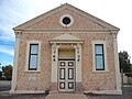 Dublin Town Hall
 -
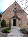 Uniting Church


See also[edit]
- District Council of Dublin
- List of cities and towns in South Australia
- Adelaide International Bird Sanctuary National Park—Winaityinaityi Pangkara
References[edit]
- ^ Australian Bureau of Statistics (28 June 2022). "Dublin (suburb and locality)". Australian Census 2021 QuickStats. Retrieved 28 June 2022.
- ^ a b c d e f g h i j "Development Plan - Mallala Council" (PDF). Department of Planning Transport and Infrastructure. pp. 248, 258 & 261. Archived from the original (PDF) on 27 February 2015. Retrieved 24 July 2015.
- ^ a b Narungga (Map). Electoral District Boundaries Commission. 2016. Retrieved 1 March 2018.
- ^ Australian Bureau of Statistics (25 October 2007). "Dublin (L) (Urban Centre/Locality)". 2006 Census QuickStats. Retrieved 8 October 2008.
- ^ "Federal electoral division of Wakefield" (PDF). Australian Electoral Commission. Retrieved 23 July 2015.
- ^ "Placename Details: Hundred of Dublin". Property Location Browser. Government of South Australia. 29 January 2009. SA0020882. Archived from the original on 7 December 2015. Retrieved 6 November 2017.
Derivation of Name: A city in Ireland; Other Details: Area 119 1/2 square miles.
- ^ "Hundred of Dublin". PlaceNames Online - South Australian State Gazetteer. Government of South Australia. Archived from the original on 30 September 2007. Retrieved 6 April 2006.
- ^ Maurovic, Richard (2007). The Meat Game: A History of the Gepps Cross Abattoirs and Livestock Markets. p. 278. ISBN 978-1-86254-726-1.
- ^ "Mallala now and then". NowAndThen.net.au. 15 September 2016.
- ^ "Mallala now and then - Dublin School". NowAndThen.net.au. 15 September 2016.
- ^ "NEWS LETTERS". The Wooroora Producer. Vol. xiii, no. 611. South Australia. 5 May 1921. p. 3. Retrieved 31 March 2018 – via National Library of Australia.
External links[edit]
- the Dublin History Group web site www.dublinhistorygroup.com.au
This South Australia geography article is a stub. You can help Wikipedia by expanding it. |