
Pakil
This article needs additional citations for verification. (July 2010) |
Pakil
Paquil | |
|---|---|
| Municipality of Pakil | |
 Pakil Municipal Hall | |
 Flag  Seal | |
| Nickname: Pilgrimage Capital of Laguna | |
 Map of Laguna with Pakil highlighted | |
OpenStreetMap  | |
.svg) Pakil Location within the Philippines | |
| Coordinates: 14°23′N 121°29′E / 14.38°N 121.48°E | |
| Country | Philippines |
| Region | Calabarzon |
| Province | Laguna |
| District | 4th district |
| Founded | 1676 |
| Barangays | 13 (see Barangays) |
| Government | |
| • Type | Sangguniang Bayan |
| • Mayor | Vincent L. Soriano |
| • Vice Mayor | Vipops Charles D. Martinez |
| • Representative | Maria Jamina Katherine B. Agarao |
| • Municipal Council | Members |
| • Electorate | 17,292 voters (2022) |
| Area | |
| • Total | 46.50 km2 (17.95 sq mi) |
| Elevation | 162 m (531 ft) |
| Highest elevation | 726 m (2,382 ft) |
| Lowest elevation | 0 m (0 ft) |
| Population (2020 census)[3] | |
| • Total | 23,495 |
| • Density | 510/km2 (1,300/sq mi) |
| • Households | 5,841 |
| Economy | |
| • Income class | 5th municipal income class |
| • Poverty incidence | 3.34 |
| • Revenue | ₱ 92.42 million (2020) |
| • Assets | ₱ 241.4 million (2020) |
| • Expenditure | ₱ 87.17 million (2020) |
| Service provider | |
| • Electricity | First Laguna Electric Cooperative (FLECO) |
| Time zone | UTC+8 (PST) |
| ZIP code | 4017 |
| PSGC | |
| IDD : area code | +63 (0)49 |
| Native languages | Tagalog |
Pakil, officially the Municipality of Pakil (Tagalog: Bayan ng Pakil), is a 5th class municipality in the province of Laguna, Philippines. According to the 2020 census, it has a population of 23,495 people.[3]
Its land area consists of two non-contiguous parts, separated by Laguna de Bay.
This town borders the town of Mabitac, to the north, Pangil, to the west, and Paete, to the south. Pakil is 19 kilometres (12 mi) from Santa Cruz and 106 kilometres (66 mi) from Manila.
History[edit]
The land from Punta Inuod to Guinabihan, Banilan is where the first settlers Gat Maitan and his wife Panumbalihan, and Gat Silayan Maginto and his wife Potongan first established themselves. After a series of raids by pirates and marauders, they moved to the present site of Poblacion, leaving behind Chief Maginoong Dalaga who ruled the place. This account explains why Pakil has two territories on the eastern and western sides of the lake. Gat Maitan and Gat Silayan are one of the borne-leaders from the ancient town of Malolos which was called by pre-colonial Chinese traders from Fujian as "Lihan" where Gats and Lacandolas abundantly reside along the shores of Manila Bay under the Kingdom of Tondo. Gat Silayan actually is one of the members of the ruling clan of Lihan whose names bearing prefix "gat" a royal title. Every member of the clan in Malolos called "Gat", and it became "Gatchalian", Gatmaitan, together with Lakandula and Gatbonton at the course of time[5][better source needed]
When the Spaniard Conquistador together with the Augustinians stationed at Bay came to the place in 1571, this colony was under the leadership of Gat Paquil, a descendant of Gat Maitan whose name was used to name the settlement as "Paquil", which remained during the whole Spanish Regime and early part of the American period. It was changed to "Pakil" by Executive Order No. 77 in 1927.[citation needed]
When the Franciscan missionaries came in 1578 Order of Friars Minor (OFM) Pakil was attached to Paete in 1602 as its "visita". Padre Francisco Barajas, made efforts to separate this town from Paete, and Don Diego Jorge became the first Capitan Municipal or Gobernadorcillo on May 12, 1676, and finally Pakil was named as an independent town with the administration of "Capitan Municipal" at the helm of the local colonial government, the last of whom was Capitan Municipal Don Nicolas Regalado.[citation needed]
With the change of government from Spanish to American upon the total Occupation of the United States in the Philippines after the defeat of the Filipino Forces in the Philippine–American War of 1898–1900, the Americans had to reorganize the pattern of the Civil Government in the country in 1901. It was Bernardo Gonzales was appointed the first Municipal President (Presidente Municipal) under American Period until November 25, 1903. Upon this reorganization, the Public Law No. 1009, of the Philippine Commission, the town of Pakil was merged with Pangil in order to reduce the number of existing towns whereas the weak towns to be merged with the stable one for the stabilization of local economy due to the damages of the previous wars. After nineteen years, On October 1, 1927, by virtue of Executive Order No. 77, Pakil was re-established into town thus the Municipality of Pakil was restored.[citation needed]
Japanese occupation[edit]
The Japanese occupation of the Philippines (Filipino: Pananakop ng mga Hapones sa Pilipinas; Japanese: 日本のフィリピン占領; Hepburn: Nihon no Firipin Senryō) occurred between 1942 and 1945, when Imperial Japan occupied the Commonwealth of the Philippines during World War II.
The invasion of the Philippines started on 8 December 1941, ten hours after the attack on Pearl Harbor. As at Pearl Harbor, American aircraft were severely damaged in the initial Japanese attack. Lacking air cover, the American Asiatic Fleet in the Philippines withdrew to Java on 12 December 1941. General Douglas MacArthur was ordered out, leaving his men at Corregidor on the night of 11 March 1942 for Australia, 4,000 km (2,500 mi) away. The 76,000 starving and sick American and Filipino defenders in Bataan surrendered on 9 April 1942, and were forced to endure the infamous Bataan Death March on which 7,000–10,000 died or were murdered. The 13,000 survivors on Corregidor surrendered on 6 May.
Japan occupied the Philippines for over three years, until the surrender of Japan. A highly effective guerilla campaign by Philippine resistance forces controlled sixty percent of the islands, mostly jungle and mountain areas. MacArthur supplied them by submarine, and sent reinforcements and officers. Filipinos remained loyal to the United States, partly because of the American guarantee of independence, and also because the Japanese had pressed large numbers of Filipinos into work details and even put young Filipino women into brothels.[1]
General MacArthur kept his promise to return to the Philippines on 20 October 1944. The landings on the island of Leyte were accompanied by a force of 700 vessels and 174,000 men. Through December 1944, the islands of Leyte and Mindoro were cleared of Japanese soldiers. During the campaign, the Imperial Japanese Army conducted a suicidal defense of the islands. Cities such as Manila were reduced to rubble. Around 500,000 Filipinos died during the Japanese Occupation Period.[2]
In 1942, the Japanese troops occupied in Pakil, Laguna and in 1945, the liberated from the Philippine Commonwealth forces under the Philippine Army and Philippine Constabulary entering in Pakil, Laguna with the local recognized guerrillas against the Japanese forces during the Second World War.
In 1954, the sitios known as Casa Real, Casinsin and Kabulusan were converted into barrios.[6][7][8] Durado followed suit in 1957.[9]
Geography[edit]
Barangays[edit]
Pakil is politically subdivided into 13 barangays. [10] Each barangay consists of puroks and some have sitios.
- Baño
- Banilan
- Burgos
- Casa Real
- Casinsin
- Dorado
- Gonzales
- Kabulusan
- Matikiw
- Rizal
- Saray
- Taft
- Tavera
Climate[edit]
| Climate data for Pakil, Laguna | |||||||||||||
|---|---|---|---|---|---|---|---|---|---|---|---|---|---|
| Month | Jan | Feb | Mar | Apr | May | Jun | Jul | Aug | Sep | Oct | Nov | Dec | Year |
| Mean daily maximum °C (°F) | 26 (79) |
27 (81) |
29 (84) |
31 (88) |
31 (88) |
30 (86) |
29 (84) |
29 (84) |
29 (84) |
29 (84) |
28 (82) |
26 (79) |
29 (84) |
| Mean daily minimum °C (°F) | 22 (72) |
22 (72) |
22 (72) |
23 (73) |
24 (75) |
25 (77) |
24 (75) |
24 (75) |
24 (75) |
24 (75) |
24 (75) |
23 (73) |
23 (74) |
| Average precipitation mm (inches) | 58 (2.3) |
41 (1.6) |
32 (1.3) |
29 (1.1) |
91 (3.6) |
143 (5.6) |
181 (7.1) |
162 (6.4) |
172 (6.8) |
164 (6.5) |
113 (4.4) |
121 (4.8) |
1,307 (51.5) |
| Average rainy days | 13.4 | 9.3 | 9.1 | 9.8 | 19.1 | 22.9 | 26.6 | 24.9 | 25.0 | 21.4 | 16.5 | 16.5 | 214.5 |
| Source: Meteoblue [11] | |||||||||||||
Demographics[edit]
| Year | Pop. | ±% p.a. |
|---|---|---|
| 1903 | 1,585 | — |
| 1939 | 2,451 | +1.22% |
| 1948 | 3,055 | +2.48% |
| 1960 | 4,765 | +3.77% |
| 1970 | 7,229 | +4.25% |
| 1975 | 8,375 | +3.00% |
| 1980 | 9,048 | +1.56% |
| 1990 | 13,438 | +4.04% |
| 1995 | 15,663 | +2.91% |
| 2000 | 18,021 | +3.05% |
| 2007 | 20,242 | +1.62% |
| 2010 | 20,822 | +1.03% |
| 2015 | 20,659 | −0.15% |
| 2020 | 23,495 | +2.56% |
| Source: Philippine Statistics Authority[12][13][14][15] | ||
In the 2020 census, the population of Pakil, Laguna, was 23,495 people,[3] with a density of 510 inhabitants per square kilometre or 1,300 inhabitants per square mile.
Economy[edit]
Graphs are unavailable due to technical issues. There is more info on Phabricator and on MediaWiki.org. |
Culture[edit]
Music was formally initiated in the town of Pakil by San Pedro Bautista (1586) the Guardian of the Franciscan order. He established the only Music Academy in the country. The school started with 400 children from towns along the Laguna Bay. These students started as church choir members and were taught how to make musical instruments out of locally available materials like bamboo, cans, wood and coconut shells. These kids were called “Tiple” and they trained other younger children to become members of the church choir.
The entire population became involved in teaching their youth to sing and play instruments. This tradition was handed down from generation to generation. The Adonay family influenced the spread of musical interest and helped form the first brass band in Pakil.
The elderly Tacio Celis helped train children to read musical notes and play instruments. Since then, many young musicians finished college on scholarships by playing for their school bands.
Currently Pakil Music Program is helping out young students to continue the rich musical heritage of the town. Pakil Music Program (PMP) is providing music education through note reading and instrument performances with the help of some retired musicians. The current executive director of the PMP is Mr. Roy Regalado.
Religion[edit]
St. Peter of Alcantara Parish[edit]
The St. Peter of Alcantara Parish, also the Diocesan Shrine of the Our Lady of Turumba is Pakil's Roman Catholic Church and home to the Our Lady of Sorrows de Turumba.
-
 Historical Marker of Pakil Church
 -
 Facade of Parochial Office
 -
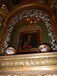 Original Painting of the Our Lady of Turumba
 -
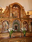 Retablo of the Turumba Chapel
 -
 Pulpito
 -
 Minor retablo with crucified Christ
 -
 Retablo Mayor of Pakil Church
 -
 The Façade of Pakil Church


Our Lady of Turumba[edit]

Nuestra Señora de los Dolores de Turumba ("Our Lady of Sorrows of Turumba") is the name for a specific statue of the Virgin Mary as Our Lady of Sorrows, enshrined in Pakil.
Liceo de Pakil[edit]
Liceo de Pakil is a private sectarian Catholic high school originally established by the Maryknoll Fathers in 1956.[23] At first, the school was named Maryknoll Fathers High School following the namesake of its leaders. When the Maryknoll Fathers had to go to their mission in Davao, they ceded the leadership to the Maryknoll Sisters who subsequently changed the school's name into Maryknoll High School. Upon the termination of the mission of the Maryknoll Sisters in 1972, Bishop Pedro N. Bantigue invited the Augustinian Recollect Sisters to administer the school. The name was changed again to Mary Immaculate Academy by the Augustinian Recollect Sisters. In 1982, the school's name was changed to Liceo De Pakil by the Diocese of San Pablo. The first batch to graduate under Liceo de Pakil was the batch of 1983 graduating class. In 1986, the administration of the school was passed on to the Missionary Catechists of St. Therese (MCST). Liceo De Pakil is currently under the administration of the MCST and the Diocese of San Pablo.[citation needed]
Notable personalities[edit]
- Marcelo Adonay - major Philippine composer and church musician.[24]
- Danilo Echavaria Dalena - modern and contemporary painter.[25][26]
- Jun Regalado - one of the most prolific drummers in the Philippines.[27]
References[edit]
- ^ Municipality of Pakil | (DILG)
- ^ "2015 Census of Population, Report No. 3 – Population, Land Area, and Population Density" (PDF). Philippine Statistics Authority. Quezon City, Philippines. August 2016. ISSN 0117-1453. Archived (PDF) from the original on May 25, 2021. Retrieved July 16, 2021.
- ^ a b c Census of Population (2020). "Region IV-A (Calabarzon)". Total Population by Province, City, Municipality and Barangay. Philippine Statistics Authority. Retrieved 8 July 2021.
- ^ "PSA Releases the 2018 Municipal and City Level Poverty Estimates". Philippine Statistics Authority. 15 December 2021. Retrieved 22 January 2022.
- ^ "PINAS: Ang Ika-3 Kaharian".
- ^ "An Act Converting the Sitio of Casa Real in Municipality of Pakil, Province of Laguna, to a Barrio to Be Known As Barrio Casa Real". LawPH.com. Retrieved 2011-04-11.
- ^ "An Act Converting the Sitio of Casinsin in the Municipality of Pakil, Province of Laguna, to a Barrio to Be Known As Barrio Casinsin". LawPH.com. Retrieved 2011-04-11.
- ^ "An Act Converting the Sitio of Kabulusan in the Municipality of Pakil, Province of Laguna, to a Barrio to Be Known As Barrio Kabulusan". LawPH.com. Retrieved 2011-04-11.
- ^ "An Act to Convert the Sitio of Durado in the Municipality of Pakil, Province of Laguna, into a Barrio to be known as the Barrio of Dorado of Said Municipality". LawPH.com. Retrieved 2011-04-12.
- ^ "Province: Laguna". PSGC Interactive. Quezon City, Philippines: Philippine Statistics Authority. Retrieved 12 November 2016.
- ^ "Pakil: Average Temperatures and Rainfall". Meteoblue. Retrieved 11 May 2020.
- ^ Census of Population (2015). "Region IV-A (Calabarzon)". Total Population by Province, City, Municipality and Barangay. Philippine Statistics Authority. Retrieved 20 June 2016.
- ^ Census of Population and Housing (2010). "Region IV-A (Calabarzon)" (PDF). Total Population by Province, City, Municipality and Barangay. National Statistics Office. Retrieved 29 June 2016.
- ^ Censuses of Population (1903–2007). "Region IV-A (Calabarzon)". Table 1. Population Enumerated in Various Censuses by Province/Highly Urbanized City: 1903 to 2007. National Statistics Office.
{{cite encyclopedia}}: CS1 maint: numeric names: authors list (link) - ^ "Province of Laguna". Municipality Population Data. Local Water Utilities Administration Research Division. Retrieved 17 December 2016.
- ^ "Poverty incidence (PI):". Philippine Statistics Authority. Retrieved December 28, 2020.
- ^ "Estimation of Local Poverty in the Philippines" (PDF). Philippine Statistics Authority. 29 November 2005.
- ^ "2003 City and Municipal Level Poverty Estimates" (PDF). Philippine Statistics Authority. 23 March 2009.
- ^ "City and Municipal Level Poverty Estimates; 2006 and 2009" (PDF). Philippine Statistics Authority. 3 August 2012.
- ^ "2012 Municipal and City Level Poverty Estimates" (PDF). Philippine Statistics Authority. 31 May 2016.
- ^ "Municipal and City Level Small Area Poverty Estimates; 2009, 2012 and 2015". Philippine Statistics Authority. 10 July 2019.
- ^ "PSA Releases the 2018 Municipal and City Level Poverty Estimates". Philippine Statistics Authority. 15 December 2021. Retrieved 22 January 2022.
- ^ Schools
- ^ "Featured Artist: Marcelo Adonay". Retrieved 2019-11-08.
- ^ "Danilo E. Dalena Biography". Retrieved 2019-11-08.
- ^ "The art of Danilo Dalena and the Filipino everyman". CNN Philippines. Archived from the original on 2019-11-07. Retrieved 2019-11-08.
- ^ "'50 Years of Drumming:' Jun Regalado marks milestone with all-star free concert". Philippine Daily Inquirer. Retrieved 2019-11-08.
External links[edit]
- Philippine Standard Geographic Code
- Philippine Census Information
- Local Governance Performance Management System Archived 2012-05-23 at the Wayback Machine
Eastern part (includes the Poblacion) | ||||||||||||||||
|---|---|---|---|---|---|---|---|---|---|---|---|---|---|---|---|---|
| ||||||||||||||||
Western part (includes barangays Banilan, Kabulusan, Casa Real, Casinsin, Dorado, Matikiw) | |
|---|---|
.svg)