
Putauaki
| Putauaki | |
|---|---|
| Mount Edgecumbe | |
 Putauaki (Mount Edgecumbe) from the north | |
| Highest point | |
| Elevation | 821 m (2,694 ft)[1] |
| Coordinates | 38°06′25″S 176°44′24″E / 38.106905°S 176.740022°E[1] |
| Geography | |
 Putauaki | |
| Geology | |
| Last eruption | 540 ± 130 BCE[2] |
Putauaki (Māori: Pūtauaki; also known in English as Mount Edgecumbe) is a dacite volcanic cone in the Bay of Plenty Region of New Zealand. Located 50 km (31 mi) east of Rotorua and three kilometres east of Kawerau, it is the easternmost vent of the Taupo Volcanic Zone adjacent to the Ōkataina volcanic centre. The mountain rises to 821 m (2,694 ft) above sea level,[1] and is visible from the waters of the Bay of Plenty, 30 km (19 mi) to the north. A King of the Mountain race was run on Putauaki as part of the international King of the Mountain series between 1955 and 2020, and proceeds were donated to charity.[3]
History[edit]
The last substantial volcanic eruption occurred at 540 ± 130 BCE, producing a cubic kilometre of lava.[4] There was a previous eruption dated to 1380 ± 50 BCE.[2]: 100 The volcano produced the Edgecumbe Formation which are pyroxene-bearing andesite to dacite lava flows, domes and minor pyroclastic tephra.[2]: 54
Captain James Cook named the mountain "Mount Edgecumbe" on 2 November 1769, possibly in honour of John Edgecombe, the sergeant of marines on his vessel, the Endeavour.[5] The mountain's official name changed back to Putauaki in 1925.[6]
The New Zealand government took part of the mountain from the Ngāti Awa people in the 1880s as part of a series of North Island land confiscations, supposedly for the purposes of military settlement. In a 1999 report the Waitangi Tribunal declared the confiscation illegal because there was no prospect of placing settlers on the mountain.[7]
Legendary source of name[edit]
Māori legend tells of a love affair that Pūtauaki had with Whakaari/White Island. Another version of the legend is that Pūtauaki was lonely after losing a fight for Pīhanga (another mountain) so when he met Tarawera he decided to start a relationship with her. After raising a son and years of a troubled marriage, Pūtauaki cast his eye out towards the sea, where the very beautiful Whakaari was. The two would call out to each other at night while Tarawera slept. One night Pūtauaki could not contain his love any longer and decided to travel out to be with Whakaari. It is said that a mountain can only move once in their life and only at night so Pūtauaki had to travel across the land fast. Little did he know, his son had awoken and was following him. He heard the little whimper from his son and turned around. He tried to tell his son to stay with Tarawera but the little mountain would not leave his father. Then the sun rose and froze the two mountains where they were. When Tarawera awoke she saw that her husband had left and she started to weep, thus creating the Tarawera Falls and river. Until this day Tarawera still cries and Whakaari still calls out for her lover, who is frozen to the spot near Kawerau.[citation needed]
Transmitter[edit]
Putauaki is home to a major FM radio transmitter for the eastern Bay of Plenty. Prior to digital television transition in December 2013, the transmitter was also the main analogue television transmitter for the area.[8][9]
| Radio Station | Transmit Frequency | Licensed power (kW) |
|---|---|---|
| The Breeze | 92.1 MHz | 1.6 |
| RNZ Concert | 95.3 MHz | 5 |
| SENZ | 96.1 MHz | 1.6 |
| Tumeke FM | 96.9 MHz | 4 |
| RNZ National | 101.7 MHz | 5 |
| The Edge | 104.1 MHz | 1.6 |
| The Sound | 105.7 MHz | 1.6 |
Gallery[edit]
-
 View of the mountain from the north
 -
 Putauaki and the Tarawera River
 -
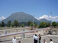 Putauaki overlooks a geothermal bore field near Kawerau
 -
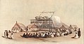 Putauaki seen in an 1847 illustration depicting a Māori feast at Matata


See also[edit]
References[edit]
- ^ a b c "NZ Topomap:Putauaki (Mount Edgecumbe), Bay of Plenty". Retrieved 16 March 2024.
- ^ a b c Leonard, G.S.; Begg, J.G.; Wilson, C.J.N. (2010). Geology of Rotorua area. 1:25000 Geological map 5 (PDF). GNS Science, Lower Hutt, New Zealand. pp. 1–102. ISBN 978-0-478-19778-5. Retrieved 16 March 2024.
- ^ "66th Kawarua King of the Mountain". Archived from the original on 24 January 2023.
- ^ "Okataina: Eruptive History". Global Volcanism Program. Smithsonian Institution.
- ^
Compare the nearby town of Edgecumbe.
Reed, A. W. (1975). The Reed Dictionary of New Zealand Place Names. Max Cryer. Auckland: Reed (published 2002). p. 131. ISBN 0790007614.
Cook may have named [the mountain] after John Edgecumbe, sergeant of the marines on the Endeavour. [...] Professor Beaglehole [...] stated there were two other possible sources - Mt Edgecumbe at Plymouth or, more probably, George Edgcumbe who became Lord Edgcumbe in 1761 and Earl of Mount-Edgcumbe in 1789, and who was a naval officer of some note.
- ^ "New Zealand Gazetteer of Official Geographic Names" (PDF). Land Information New Zealand. Retrieved 23 March 2011.[permanent dead link]
- ^ "Ngati Awa Raupatu Report, chapter 10, Waitangi Tribunal, 1999". Archived from the original on 2007-03-17. Retrieved 2008-06-26.
- ^ "Home". Radio Spectrum Management. Retrieved 2021-11-04.
- ^ "New Zealand Television Transmission Stations in Operation – North Island" (PDF). Kordia. 31 March 2008. Archived from the original (PDF) on 7 March 2014. Retrieved 22 July 2013.