
Sande, Møre og Romsdal
Sande Municipality
Sande kommune | |
|---|---|
| Sandø herred (historic name) | |
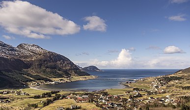
 View of the Rovdefjorden (Sande is to the left) | |
.gif) Flag | |
 Møre og Romsdal within Norway | |
 Sande within Møre og Romsdal | |
| Coordinates: 62°15′30″N 05°25′53″E / 62.25833°N 5.43139°E | |
| Country | Norway |
| County | Møre og Romsdal |
| District | Sunnmøre |
| Established | 1 Jan 1867 |
| • Preceded by | Herøy Municipality |
| Administrative centre | Larsnes |
| Government | |
| • Mayor (2023) | Dag Arne Vaagen (H) |
| Area | |
| • Total | 93.24 km2 (36.00 sq mi) |
| • Land | 90.17 km2 (34.81 sq mi) |
| • Water | 3.07 km2 (1.19 sq mi) 3.3% |
| • Rank | #331 in Norway |
| Population (2023) | |
| • Total | 2,442 |
| • Rank | #257 in Norway |
| • Density | 27.1/km2 (70/sq mi) |
| • Change (10 years) | |
| Demonym | Sandeværing[1] |
| Official language | |
| • Norwegian form | Nynorsk |
| Time zone | UTC+01:00 (CET) |
| • Summer (DST) | UTC+02:00 (CEST) |
| ISO 3166 code | NO-1514[3] |
| Website | Official website |

Sande is a municipality in Møre og Romsdal county, Norway. It is part of the Sunnmøre region. The administrative centre is the village of Larsnes on the island of Gurskøya. Other villages in Sande include Gursken, Sandshamn, Bringsinghaug, and Voksa.
The 93-square-kilometre (36 sq mi) municipality is the 331st largest by area out of the 356 municipalities in Norway. Sande is the 257th most populous municipality in Norway with a population of 2,442. The municipality's population density is 27.1 inhabitants per square kilometre (70/sq mi) and its population has decreased by 7.1% over the previous 10-year period.[4][5]
General information[edit]


Sande was established as a municipality on 1 January 1867 when it was separated from the large Herøy Municipality. The initial population was 2,493. On 1 January 1873, a part of eastern Sande (with 362 residents) was transferred back to Herøy. On 1 January 1889, the Eksund area and the island of Ekø (population: 119) were transferred to Herøy Municipality.[6]
On 1 January 1905, the eastern district of Sande was separated to form the separate municipality of Rovde. This left Sande with 2,221 residents. During the 1960s, there were many municipal mergers across Norway due to the work of the Schei Committee. On 1 January 1964, the northern part of the municipality of Rovde (population: 562) plus three farms in the Gurskedalen valley (population: 25) were merged back with Sande (the southern part of Rovde was merged with Vanylven Municipality). The new Sande municipality had a population of 3,465. On 1 January 2002, the Åram area (population: 380) on the mainland was transferred from Sande to Vanylven Municipality.[6][7]
Name[edit]
The municipality (originally the parish) is named after the old Sande farm (Old Norse: Sandr) since the first Sande Church was built there. The name comes from the word sandr which means "sand" or "sandy beach". Before 1892, the name was written Sandø.[8]
Coat of arms[edit]
The coat of arms was granted on 23 October 1987. The official blazon is "Azure, a line buoy argent" (Norwegian: På blå grunn ei sølv linebøye). This means the arms have a blue field (background) and the charge is a line buoy. The line buoy has a tincture of argent which means it is commonly colored white, but if it is made out of metal, then silver is used. The blue color in the field symbolizes the importance of the sea. This symbol was chosen since it was historically used by fishermen in ocean and fjords around the island municipality. The arms were designed by Jarle Skuseth who based it off an idea from Helge Kragseth. The municipal flag has the same design as the coat of arms.[9][10][11]
Churches[edit]
The Church of Norway has two parishes (sokn) within the municipality of Sande. It is part of the Søre Sunnmøre prosti (deanery) in the Diocese of Møre.
| Parish (sokn) | Church name | Location of the church | Year built |
|---|---|---|---|
| Sande | Sande Church | Sande on Sandsøya | 1880 |
| Gursken | Gursken Church | Gursken | 1919 |
| Larsnes Chapel | Larsnes | 1989 |
Geography[edit]
Sande is composed of many islands including Sandsøya, Kvamsøya, Voksa, Riste, and part of Gurskøya (which is shared with neighboring Herøy). The island municipality sits north of the Rovdefjorden and east of the Vanylvsfjorden. The Haugsholmen Lighthouse sits in the southwest part of the municipality.
Government[edit]
Sande Municipality is responsible for primary education (through 10th grade), outpatient health services, senior citizen services, welfare and other social services, zoning, economic development, and municipal roads and utilities. The municipality is governed by a municipal council of directly elected representatives. The mayor is indirectly elected by a vote of the municipal council.[12] The municipality is under the jurisdiction of the Møre og Romsdal District Court and the Frostating Court of Appeal.
Municipal council[edit]
The municipal council (Kommunestyre) of Sande is made up of 21 representatives that are elected to four year terms. The tables below show the current and historical composition of the council by political party.
| Party name (in Nynorsk) | Number of representatives | |
|---|---|---|
| Labour Party (Arbeidarpartiet) | 5 | |
| Progress Party (Framstegspartiet) | 3 | |
| Conservative Party (Høgre) | 9 | |
| Centre Party (Senterpartiet) | 4 | |
| Total number of members: | 21 | |
| Party name (in Nynorsk) | Number of representatives | |
|---|---|---|
| Labour Party (Arbeidarpartiet) | 4 | |
| Progress Party (Framstegspartiet) | 3 | |
| Conservative Party (Høgre) | 8 | |
| Centre Party (Senterpartiet) | 4 | |
| Cross-party list: Kvamsøy, Sandsøy, Voksa (Tverrpolitisk liste: Kvamsøy, Sandsøy, Voksa) | 2 | |
| Total number of members: | 21 | |
| Party name (in Nynorsk) | Number of representatives | |
|---|---|---|
| Labour Party (Arbeidarpartiet) | 5 | |
| Progress Party (Framstegspartiet) | 2 | |
| Conservative Party (Høgre) | 7 | |
| Centre Party (Senterpartiet) | 2 | |
| Liberal Party (Venstre) | 1 | |
| Cross-party list: Kvamsøy, Sandsøy, Voksa (Tverrpolitisk liste: Kvamsøy, Sandsøy, Voksa) | 4 | |
| Total number of members: | 21 | |
| Party name (in Nynorsk) | Number of representatives | |
|---|---|---|
| Labour Party (Arbeidarpartiet) | 2 | |
| Progress Party (Framstegspartiet) | 2 | |
| Conservative Party (Høgre) | 8 | |
| Christian Democratic Party (Kristeleg Folkeparti) | 1 | |
| Centre Party (Senterpartiet) | 2 | |
| Liberal Party (Venstre) | 2 | |
| Cross-party list: Kvamsøy, Sandsøy, Voksa (Tverrpolitisk liste: Kvamsøy, Sandsøy, Voksa) | 4 | |
| Total number of members: | 21 | |
| Party name (in Nynorsk) | Number of representatives | |
|---|---|---|
| Labour Party (Arbeidarpartiet) | 2 | |
| Progress Party (Framstegspartiet) | 3 | |
| Conservative Party (Høgre) | 5 | |
| Christian Democratic Party (Kristeleg Folkeparti) | 2 | |
| Centre Party (Senterpartiet) | 4 | |
| Cross-party list for Kvamsøy, Sandsøy, and Voksa (Tverrpolitisk liste for Kvamsøy, Sandsøy og Voksa) | 5 | |
| Total number of members: | 21 | |
| Party name (in Nynorsk) | Number of representatives | |
|---|---|---|
| Labour Party (Arbeidarpartiet) | 2 | |
| Progress Party (Framstegspartiet) | 3 | |
| Conservative Party (Høgre) | 4 | |
| Christian Democratic Party (Kristeleg Folkeparti) | 2 | |
| Centre Party (Senterpartiet) | 3 | |
| Socialist Left Party (Sosialistisk Venstreparti) | 3 | |
| Cross-party list for Kvamsøy, Sandsøy, and Voksa (Tverrpolitisk liste for Kvamsøy, Sandsøy og Voksa) | 4 | |
| Total number of members: | 21 | |
| Party name (in Nynorsk) | Number of representatives | |
|---|---|---|
| Labour Party (Arbeidarpartiet) | 4 | |
| Conservative Party (Høgre) | 8 | |
| Christian Democratic Party (Kristeleg Folkeparti) | 4 | |
| Centre Party (Senterpartiet) | 1 | |
| Cross-party list for Åram, Kvamsøy, and Sandsøy (Tverrpolitisk liste for Åram, Kvamsøy og Sandsøy) | 7 | |
| Local list for Gjerdsvika (Bygdaliste for Gjerdsvika) | 5 | |
| Total number of members: | 29 | |
| Party name (in Nynorsk) | Number of representatives | |
|---|---|---|
| Labour Party (Arbeidarpartiet) | 3 | |
| Conservative Party (Høgre) | 5 | |
| Christian Democratic Party (Kristeleg Folkeparti) | 3 | |
| Centre Party (Senterpartiet) | 1 | |
| Liberal Party (Venstre) | 1 | |
| Cross-party list for Åram, Kvamsøy, and Sandsøy (Tverrpolitisk liste for Åram, Kvamsøy og Sandsøy) | 9 | |
| Election list for Gjerdsvika, Haugsbygda, and Vågen (Valliste for Gjerdsvika, Haugsbygda og Vågen) | 7 | |
| Total number of members: | 29 | |
| Party name (in Nynorsk) | Number of representatives | |
|---|---|---|
| Labour Party (Arbeidarpartiet) | 1 | |
| Conservative Party (Høgre) | 5 | |
| Christian Democratic Party (Kristeleg Folkeparti) | 3 | |
| Centre Party (Senterpartiet) | 1 | |
| Socialist Left Party (Sosialistisk Venstreparti) | 1 | |
| Liberal Party (Venstre) | 1 | |
| Cross-party list for Åram, Kvamsøy, and Sandsøy (Tverrpolitisk liste for Åram, Kvamsøy og Sandsøy) | 9 | |
| Election list for Gjerdsvika, Haugsbygda, and Vågen (Valliste for Gjerdsvika, Haugsbygda og Vågen) | 8 | |
| Total number of members: | 29 | |
| Party name (in Nynorsk) | Number of representatives | |
|---|---|---|
| Labour Party (Arbeidarpartiet) | 4 | |
| Conservative Party (Høgre) | 5 | |
| Christian Democratic Party (Kristeleg Folkeparti) | 5 | |
| Centre Party (Senterpartiet) | 1 | |
| Socialist Left Party (Sosialistisk Venstreparti) | 1 | |
| Liberal Party (Venstre) | 2 | |
| Cross-party list for Åram, Kvamsøy, and Sandsøy (Tverrrpolitisk liste for Åram, Kvamsøy og Sandsøy) | 11 | |
| Total number of members: | 29 | |
| Party name (in Nynorsk) | Number of representatives | |
|---|---|---|
| Labour Party (Arbeidarpartiet) | 6 | |
| Conservative Party (Høgre) | 6 | |
| Christian Democratic Party (Kristeleg Folkeparti) | 7 | |
| Centre Party (Senterpartiet) | 3 | |
| Liberal Party (Venstre) | 5 | |
| List for Hakallestranda and Sørbrandal (Liste for Hakallestranda og Sørbrandal) | 2 | |
| Total number of members: | 29 | |
| Party name (in Nynorsk) | Number of representatives | |
|---|---|---|
| Labour Party (Arbeidarpartiet) | 4 | |
| Conservative Party (Høgre) | 7 | |
| Christian Democratic Party (Kristeleg Folkeparti) | 9 | |
| Centre Party (Senterpartiet) | 4 | |
| Liberal Party (Venstre) | 5 | |
| Common list for Hallebygda, Larsnes, and Skredestranda (Samlingsliste for Hallebygda, Larsnes og Skredestranda) | 1 | |
| Election list for the Åram area (Valliste for Åram krets) | 3 | |
| Total number of members: | 33 | |
| Party name (in Nynorsk) | Number of representatives | |
|---|---|---|
| Labour Party (Arbeidarpartiet) | 3 | |
| Conservative Party (Høgre) | 2 | |
| Local list for Kvamsøy (Krinsliste for Kvamsøy) | 3 | |
| Election list for the Åram area (Valliste for Åram Krins) | 3 | |
| Joint list of the Centre Party (Senterpartiet), Christian Democratic Party (Kristeleg Folkeparti), and Liberal Party (Venstre) | 11 | |
| Local list for Sandsøy and Voksa (Krinsliste for Sandsøy og Voksa) | 1 | |
| Election list for the Gjerdsvika area (Valliste for Gjerdsvika krins) | 2 | |
| Common list for V[gen and Haugsbygda (Samlingsliste for Vågen og Haugsbygda) | 5 | |
| Common list for Halleberg, Larsnes and Skredestranda (Samlingsliste for Halleberg, Larsnes og Skredestranda) | 3 | |
| Total number of members: | 33 | |
| Party name (in Nynorsk) | Number of representatives | |
|---|---|---|
| Labour Party (Arbeidarpartiet) | 3 | |
| Conservative Party (Høgre) | 2 | |
| Christian Democratic Party (Kristeleg Folkeparti) | 4 | |
| Centre Party (Senterpartiet) | 5 | |
| Liberal Party (Venstre) | 5 | |
| Local List(s) (Lokale lister) | 14 | |
| Total number of members: | 33 | |
| Party name (in Nynorsk) | Number of representatives | |
|---|---|---|
| Labour Party (Arbeidarpartiet) | 5 | |
| Conservative Party (Høgre) | 3 | |
| Christian Democratic Party (Kristeleg Folkeparti) | 9 | |
| Centre Party (Senterpartiet) | 6 | |
| Liberal Party (Venstre) | 10 | |
| Total number of members: | 33 | |
| Party name (in Nynorsk) | Number of representatives | |
|---|---|---|
| Local List(s) (Lokale lister) | 33 | |
| Total number of members: | 33 | |
| Party name (in Nynorsk) | Number of representatives | |
|---|---|---|
| Local List(s) (Lokale lister) | 33 | |
| Total number of members: | 33 | |
| Party name (in Nynorsk) | Number of representatives | |
|---|---|---|
| List of workers, fishermen, and small farmholders (Arbeidarar, fiskarar, småbrukarar liste) | 2 | |
| Local List(s) (Lokale lister) | 31 | |
| Total number of members: | 33 | |
| Party name (in Nynorsk) | Number of representatives | |
|---|---|---|
| Local List(s) (Lokale lister) | 32 | |
| Total number of members: | 32 | |
| Party name (in Nynorsk) | Number of representatives | |
|---|---|---|
| Local List(s) (Lokale lister) | 32 | |
| Total number of members: | 32 | |
| Party name (in Nynorsk) | Number of representatives | |
|---|---|---|
| Local List(s) (Lokale lister) | 32 | |
| Total number of members: | 32 | |
| Party name (in Nynorsk) | Number of representatives | |
|---|---|---|
| Labour Party (Arbeidarpartiet) | 7 | |
| Local List(s) (Lokale lister) | 25 | |
| Total number of members: | 32 | |
| Note: Due to the German occupation of Norway during World War II, no elections were held for new municipal councils until after the war ended in 1945. | ||
Mayors[edit]
The mayors (Nynorsk: ordførar) of Sande:
- 1867–1870: Knut R. Bjørlykke
- 1871–1880: Bendt L. Redse
- 1881–1898: Rasmus K. Sætre
- 1899–1905: Daniel D. Liset
- 1905–1919: Hans J. Aaram
- 1920–1922: Ole S. Dyrkoren
- 1923–1937: August A. Kragset
- 1938–1941: Jakob Sætre
- 1941–1941: Torvald Baade (NS)
- 1941–1945: Oskar Sandanger (NS)
- 1945–1947: Jakob Sætre
- 1948–1951: Sverre Myklebust
- 1952–1955: Torvald Baade
- 1956–1957: Sverre Myklebust
- 1958–1975: Petter H. Kragset (V)
- 1976–1981: John Gjerde (V)
- 1982–1983: Jon Martin Bringsvor (H)
- 1984–1987: John Gjerde (V)
- 1988–2003: Arne Dyrhol (H)
- 2003–2007: Jon Garen (Sp)
- 2007–2019: Dag Arne Vaagen (H)
- 2019–2023: Olav Myklebust (Sp)
- 2023-present: Dag Arne Vaagen (H)
Notable people[edit]
- Ingolf Rogde (1911 in Haugsholmen, Sande – 1978), a Norwegian actor with the touring theatre Riksteatret[32]
- Bjartmar Gjerde (1931 in Larsnes, Sande – 2009), a politician, government minister, and DG of the Norwegian Broadcasting Corporation
- Odd S. Lovoll (born 1934 in Sande), a Norwegian-American author, historian, educator, and academic
- Morten Schakenda (born 1966 in Gjerdsvika, Sande), a Norwegian cook and leading chef
- Jan Åge Fjørtoft (born 1967 in Gursken, Sande), a former footballer with 497 club caps and 71 for Norway
Gallery[edit]
-
 Gjerdsvika
 -
 Sande kirke i Møre og Romsdal
 -
 Dragsundbrua Access South


References[edit]
- ^ "Navn på steder og personer: Innbyggjarnamn" (in Norwegian). Språkrådet.
- ^ "Forskrift om målvedtak i kommunar og fylkeskommunar" (in Norwegian). Lovdata.no.
- ^ Bolstad, Erik; Thorsnæs, Geir, eds. (26 January 2023). "Kommunenummer". Store norske leksikon (in Norwegian). Kunnskapsforlaget.
- ^ Statistisk sentralbyrå. "Table: 06913: Population 1 January and population changes during the calendar year (M)" (in Norwegian).
- ^ Statistisk sentralbyrå. "09280: Area of land and fresh water (km²) (M)" (in Norwegian).
- ^ a b Jukvam, Dag (1999). Historisk oversikt over endringer i kommune- og fylkesinndelingen (PDF) (in Norwegian). Statistisk sentralbyrå. ISBN 9788253746845.
- ^ Statistisk sentralbyrå (2001). "1511 Vanylven. Population 1 January and population changes during the year. 1951-" (in Norwegian).
- ^ Rygh, Oluf (1908). Norske gaardnavne: Romsdals amt (in Norwegian) (13 ed.). Kristiania, Norge: W. C. Fabritius & sønners bogtrikkeri. p. 18 and 27.
- ^ "Civic heraldry of Norway - Norske Kommunevåpen". Heraldry of the World. Retrieved 15 April 2023.
- ^ "Sande, Møre og Romsdal (Norway)". Flags of the World. Retrieved 15 April 2023.
- ^ "Godkjenning av våpen og flagg". Lovdata.no (in Norwegian). Norges kommunal- og arbeidsdepartementet. 23 October 1987. Retrieved 15 April 2023.
- ^ Hansen, Tore; Vabo, Signy Irene, eds. (20 September 2022). "kommunestyre". Store norske leksikon (in Norwegian). Kunnskapsforlaget. Retrieved 14 October 2022.
- ^ "Kommunestyrevalg 2023 - Møre og Romsdal". Valgdirektoratet. Retrieved 16 January 2024.
- ^ "Kommunestyrevalg 2019 – Møre og Romsdal". Valgdirektoratet. Retrieved 19 October 2019.
- ^ a b c d "Table: 04813: Members of the local councils, by party/electoral list at the Municipal Council election (M)" (in Norwegian). Statistics Norway.
- ^ "Kommunestyrevalg 2011 – Møre og Romsdal". Valgdirektoratet. Retrieved 19 October 2019.
- ^ "Kommunestyrevalget 1995" (PDF) (in Norwegian). Oslo-Kongsvinger: Statistisk sentralbyrå. 1996. Retrieved 1 May 2020.
- ^ "Kommunestyrevalget 1991" (PDF) (in Norwegian). Oslo-Kongsvinger: Statistisk sentralbyrå. 1993. Retrieved 1 May 2020.
- ^ "Kommunestyrevalget 1987" (PDF) (in Norwegian). Oslo-Kongsvinger: Statistisk sentralbyrå. 1988. Retrieved 1 May 2020.
- ^ "Kommunestyrevalget 1983" (PDF) (in Norwegian). Oslo-Kongsvinger: Statistisk sentralbyrå. 1984. Retrieved 1 May 2020.
- ^ "Kommunestyrevalget 1979" (PDF) (in Norwegian). Oslo: Statistisk sentralbyrå. 1979. Retrieved 1 May 2020.
- ^ "Kommunevalgene 1975" (PDF) (in Norwegian). Oslo: Statistisk sentralbyrå. 1977. Retrieved 1 May 2020.
- ^ "Kommunevalgene 1972" (PDF) (in Norwegian). Oslo: Statistisk sentralbyrå. 1973. Retrieved 1 May 2020.
- ^ "Kommunevalgene 1967" (PDF) (in Norwegian). Oslo: Statistisk sentralbyrå. 1967. Retrieved 1 May 2020.
- ^ "Kommunevalgene 1963" (PDF) (in Norwegian). Oslo: Statistisk sentralbyrå. 1964. Retrieved 1 May 2020.
- ^ "Kommunevalgene og Ordførervalgene 1959" (PDF) (in Norwegian). Oslo: Statistisk sentralbyrå. 1960. Retrieved 1 May 2020.
- ^ "Kommunevalgene og Ordførervalgene 1955" (PDF) (in Norwegian). Oslo: Statistisk sentralbyrå. 1957. Retrieved 1 May 2020.
- ^ "Kommunevalgene og Ordførervalgene 1951" (PDF) (in Norwegian). Oslo: Statistisk sentralbyrå. 1952. Retrieved 1 May 2020.
- ^ "Kommunevalgene og Ordførervalgene 1947" (PDF) (in Norwegian). Oslo: Statistisk sentralbyrå. 1948. Retrieved 1 May 2020.
- ^ "Kommunevalgene og Ordførervalgene 1945" (PDF) (in Norwegian). Oslo: Statistisk sentralbyrå. 1947. Retrieved 1 May 2020.
- ^ "Kommunevalgene og Ordførervalgene 1937" (PDF) (in Norwegian). Oslo: Statistisk sentralbyrå. 1938. Retrieved 1 May 2020.
- ^ Ingolf Rogde at IMDb. Retrieved 26 March 2021.
External links[edit]
- Municipal fact sheet from Statistics Norway (in Norwegian)
 Media related to Sande, Møre og Romsdal at Wikimedia Commons
 Møre og Romsdal travel guide from Wikivoyage
Møre og Romsdal county, Norway | |||||||
|---|---|---|---|---|---|---|---|
| |||||||
 | Towns & cities |
| |||||
| Municipalities |
| ||||||
| |||||||
| International | |
|---|---|
| National | |
| Geographic | |